
Transcript - Rail Crossing virtual open house recording June 1, 2022
Jennifer: Okay, so recording has begun. And before I begin, I'd like to introduce the project team members who are here tonight. Our lead project manager and co-presenter tonight that you'll hear from is Daniel Di Pietro from our transportation planning division. We also have Kelly Guthrie, community engagement coordinator, and tonight's facilitator. Our transportation planning engineer is behind the scenes. Her name is Gwen Zhang, and she has been supporting our transportation modeling and technical analyses. Shelly Reed is also behind the scenes today and is our strategic communications advisor. The city has retained Parsons Consulting to complete this feasibility study. So we have some of their members with us tonight as well. Altaf Hussain, our project manager and Selina Chen environmental planner are with us tonight to help respond to some of the technical questions that might come up later this evening. And my name is Jennifer Juste. I am the manager of transportation planning with the city.
So the remainder of tonight's session will include going over some general housekeeping for the open house, such as how to use WebEx and ask questions. We'll do an overview of the feasibility study and we'll explain the next steps after the completion of the study. Then we'll move into the question and answer portion of tonight's open house. I'm going to pass it over to Kelly Guthrie to take us through tonight's housekeeping items.
Go ahead, Kelly.
Kelly: Hello, everyone. I just saw on the chat that someone has mentioned that there's no sound, so I was trying to reply to them. But I will do that after. So hopefully by now we have gotten used to using all of these virtual programs and platforms, but just to be sure, I'm going to go through some key features. So all of the participants, except for the presenters will be muted until the question and answer begins. And that will happen after the presentation. You can use the reactions which are located if you hover over your name, the reactions will happen to indicate to us if we're speaking too fast. You can use the chat function at any time to enter your questions.
However, presenters will not answer questions during the presentation. We're going to answer all of your questions afterwards. During the question and answer, I'm going to do my best to answer as many of your questions from the chat as possible in the time that we have. If your question is not answered tonight, don't worry about that. Please be reassured that we're going to look at all of the questions in the chat. Anything that we haven't been able to answer, we're going to answer on, haveyoursay.guelph.ca in the days following the presentation.
So we want to make sure that this is an accessible space for everyone. So please let us know if there's any other way that you wish to participate. And lastly, please stay connected. We'll be posting information online with the transcript and the presentation that we're recording this evening and our discussion for anyone who misses tonight's event or for anyone who might want to revisit certain information later. So comments are open on have your say.Guelph.CA for the rail crossing study until June 22nd. So if you have a comment later on and you don't ask it tonight, please feel free to use that comment function then. And back to you, Jenny.
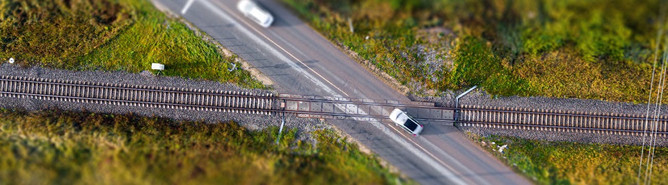
Jennifer: Thanks, Kelly. All right, now let's get into it. If you do have any further questions about hearing me or any technical glitches, just put a chat in the chat function there, and Kelly will try to help and resolve that for you. Okay. So what are we talking about tonight? A level rail crossing is when a railway line intersects a road at the same elevation. An example can be seen on the screen. In tonight's presentation, you'll hear us refer to it either as a level rail crossing or LRC fairly often. The city of Guelph top priority is public safety and maintaining connectivity in our communities. A few years ago, Metrolinx began a review of level rail crossings in Guelph as part of the Metrolinx plans for two-way all day go service between Kitchener and Union station. The two-way all day go plans currently include increased frequency and speed of trains between now and 2041. To comply with the changes to transport Canada regulations, and to be able to safely deliver these planned services, Metrolinx had to close the level rail crossing at Dublin Street in 2020.
Public engagement was limited because this was a regulatory change that couldn't be influenced by the public. Residents understandably, felt frustrated that their concerns were not considered, and some are still afraid that other crossing closures are planned. So in response, the city's proactively studying the impacts of any potential future level rail crossing closure along the Metrolinx Corridor. Now recently Metrolinx indicated that they have no plans to close any additional level rail crossings in Guelph, which is great news. And we're really pleased to hear that. However, we've decided to keep going with this study because there's still a few unlikely scenarios that could trigger reconsideration of that decision for existing level rail crossings. These could include provincially directed changes to Metrolinx service that further increases speed or frequency of trains beyond what they've currently proposed or could include Transport Canada safety and design standard changes, or if there are growing and changing travel patterns in the city beyond what we've currently projected. So just to reiterate, there are no closures required any further at any existing level rail crossing, as far as we know on the Metrolinx line in Guelph for the foreseeable future.
So what is a transportation and feasibility study? It's a high level conceptual study, and it's the very first step in determining if anything further needs to be done. And this one there's two parts in our study. The first part is an analysis of the existing level rail crossings to help us understand the impacts to the transportation network for all modes of travel. The second part is an assessment of three potential active transportation only crossings. For the first part, the transportation study component of this work, the consultants collected and analyzed the movement of people by all forms of transportation, walking, cycling, and driving on the local road network. Then they tested the impacts of possible changes to the crossings within that network. So for example, what would happen if we close road A at the rail line or maintain access, how does that affect the side streets and the other intersections in the area?
The focus is on assessing transportation impacts such as traffic, performance, safety, and connectivity. The feasibility part of the study looked at different types of crossings. Underpass, overpass, closing it, keeping it at grade, and looked at what was the most possible to construct and which would help the road network function at its best. The image on the right that you can see is how a feasibility study fits into the city of Guelph's hierarchy of plans and processes. At the top, you have the city of Guelph official plan, which directs how the city grows and develops as our population changes.
The master plans and secondary plans come out of that. So for example, the Guelph transportation master plan identifies actions such as future studies and network improvements that ensure that we can move people through our community now and into the future, based on the development, objectives, and goals of the official plan. This feasibility study comes out of our transportation master plan to address maintaining and improving connectivity. So it's the first step in considering connectivity improvements across the rail corridor and determining if any grade separation may be warranted. We'll talk a little bit more about the next steps after that at the end of this presentation. So I'm going to pass it over now to Daniel, our project manager, to start going into some of the details of the study.
Daniel: Great, thanks Jenny. Next, we're going to take a look at the level rail crossing study areas. As described earlier, the feasibility study is split into two parts. Part one is the existing level rail crossing transportation study that looks at two study areas, A and B as seen on the screen. Study area A includes the crossing of Alma Street, Edinburgh Road, Yorkshire Street, and Glasgow Street. Edinburgh Road is impacted the most as it is an arterial road that carries a much higher number of vehicles than the other local streets listed. Study area B includes the crossing of Watson Road North just north of York Road. Part two of the study includes reviewing the feasibility of potential active transportation crossings at Margaret Greene Park, Cityview Drive North and Dublin Street North. They can be seen on the study area maps marked as a star.
So next we're going to go into the rail crossing options. The various rail crossing options that were evaluated during the feasibility study can be seen here. The first option is maintaining the level rail crossing at each location. Then we have the overpass option where you can have the road passing over the railway track. Next is an underpass where the road passes below the railway tracks. Lastly, road closures were also considered as part of the transportation study so that we can understand how the rest of the road network and connectivity of the community would be impacted. All options are assumed to include active transportation facilities. So next, moving on to public and stakeholder con consultation, this slide summarizes how we are engaging with you and stakeholders throughout this study. As a reminder, this is a proactive study to understand how rail crossing closures would impact our community before any changes are actually indicated.
We started in the fall of 2021 with an opportunity for the public to provide feedback on this study through an interactive survey on our haveyoursay website. We've also been consulting with specific stakeholders, such as Metrolinx Guelph Coalition for Active Transportation, and school boards. This current round of engagement will include this public open house and an opportunity to provide comments and feedback online until June 22nd. So what do we hear from our initial survey? We received over 1700 responses to the survey and appreciate your patience as we worked on getting answers to them. We heard that there's a strong desire to maintain vehicular and active transportation connectivity between neighborhoods on both sides of the Metrolinx rail corridor.
We heard that traffic can be an existing problem around these rail crossings and closing them would create increased congestion on adjacent roads. Edinburgh road, as we expected, should remain open to vehicular traffic. We heard that Dublin Street closure has had a negative impact on the community. Requests were made to reopen the crossing either to all traffic or only active transportation. And as a response to this, we have added consideration of an active transportation only crossing at Dublin Street as part of this study. Concerns were expressed about the noise, speed, and interruptions from Metrolinx and CN operations on the railroad tracks.
We also heard that there was interest in exploring a new active transportation only crossing at Margaret Greene Park and Cityview Drive. In response, we added these to our study as well. So just a quick thing I see here, can you please define what active transportation means? Just a quick note on that. Active transportation includes pedestrian so walking cyclists, rollerblading, anything that isn't a motorized vehicle, including mobility devices, scooters. Thank you. So next, we're going to go to the existing level rail crossing analysis, which is part one of our study. So next few slides we'll review the result of the feasibility study. Study Area A includes four level rail crossings that were evaluated together due to their proximity and function in the local road network. The crossings include Alma Street, Edinburgh Road, Yorkshire Street, and Glasgow Street.
So the existing conditions of study Area A. So for study area A, data was collected and traffic patterns were analyzed within the highlighted area you see on screen. It is bounded by Paisley Road to the north, Wellington Street to the south, Silvercreek Parkway to the west and Gordon Street/Norfolk street to the east. When conducting a transportation study, the first thing you need to consider is how the network currently operates. This is what we call existing conditions. So under existing conditions, we found that Edinburgh Road serves significantly more peak hour traffic than the other three crossings. This is because Edinburgh Road is an arterial road and carries more traffic than the local roads that serve just the adjacent residences. We observed that the traffic from Dublin Street is being diverted to Glasgow and Yorkshire streets. We also observed that the pedestrian and cyclist counts were typically highest during the weekends and in the PM peak period.
Lastly, Silvercreek Parkway does not currently connect across the Metrolinx rail corridor. So in order to do our future traffic study, we needed to come up with scenarios. And in order to do that, we needed to develop criteria to narrow them down. So for study area A, there are many potential combinations of scenarios to consider. For example, each road had four potential options, to be closed, to have an overpass, an underpass, or remain at-grade. In addition, there's a consideration of whether Silvercreek is connected in the future or remains closed at Metrolinx at the Metrolinx rail corridor. This resulted in a large amount of potential scenarios.
So the consultants developed criteria to weed out the least feasible options and select the most feasible scenarios to explore in more detail. A fatal flaw analysis was conducted to rule out alternatives that didn't meet minimum requirements. For example, that couldn't be constructed with the existing right of way within the existing right of way, that didn't meet transportation needs, or that couldn't meet accessibility design standards. Seven of the best scenarios that minimize significant property, environmental and or construction cost impacts were selected for further analysis in the study.
So we're going to move on to scenarios that were chosen. So this table summarizes the seven scenarios that were not eliminated through the fatal flaw screening. Each of these scenarios were further analyzed to determine future traffic impacts at 2041. The do nothing scenario means that the crossing would remain as a level rail crossing. Where crossings were considered to be closed, an active transportation only crossing would be considered in that location. So going through the table, starting with the first scenario, scenario A one is to do nothing scenario, which maintains a level rail crossing at all locations. Scenario A two is considering a grade separation, either an overpass or underpass at each location. Scenario A three is considering the closing of all local streets and retaining only Edinburgh Road open as a level rail crossing. Scenario A four considers the closure of all local streets and a grade separation at Edinburgh Road. Scenario A five considers closing Alma and Glasgow while maintaining both Edinburgh and Yorkshire as level rail crossings. Scenario A six considers closing Alma and Glasgow, maintains Yorkshire as a level rail crossing and assumes Edinburgh Road is grade separated.
And lastly, scenario A seven considers maintaining all local streets as level rail crossings and only Edinburgh Road for grade separation. So looking at our future 2041 traffic analysis, when assessing the future scenarios, we also considered the current and future plans for Silvercreek Parkway. Silvercreek does not currently connect across the Metrolinx rail corridor as mentioned earlier. However, there is an active development application that proposes connecting this road under the tracks. So scenarios A one to A seven were analyzed under both assumptions. One, that Silvercreek is connected and two that Silvercreek remains closed. A warrant analysis for grade separation at each crossing was completed according to the Transport Canada grade separation assessment guidelines using the forecasted future traffic conditions. At Alma, Yorkshire, and Glasgow only the queue length criterion was met for grade separation. The criterion was met because projected queue lengths could be more than 30 meters and could block existing driveways.
However, given the low density residential nature of this area, this isn't considered a major trigger for further consideration of grade separation. In addition to the warrant analysis, the traffic study indicated that existing level rail crossings can be maintained for the short term with the exception of Edinburgh Road crossing, where grade separation should be considered based on significant queuing vehicle delays and rail/traffic volume analysis. For the long term, the study indicates staff should continue to monitor traffic operations and safety at the other rail crossings, meaning Yorkshire, Alma, and Glasgow.
So moving on to evaluation criteria. So the information on the previous slide was describing strictly traffic conditions. This is not the only criteria used to rank the seven scenarios. Next, we will introduce the evaluation criteria we use to select a preferred scenario for study area A. The following criteria were used. Local traffic circulation considered how well the option minimized traffic impacts the local neighborhoods. Connectivity considered how well the scenario reduced physical barriers to the transportation across the rail corridor. Traffic operations preferred the scenarios that allowed for better traffic performance under future conditions. City planning and operations guidelines evaluated how well the alternatives aligned with our current plans and policies such as the transportation master plan. Construct ability evaluated how easy construction efforts would be. And property impacts considered the extent to which properties would be affected. Cost aspects were also considered. Higher cost options would score lower than affordable options.
So moving on to the evaluation of scenarios. So here's how the scenarios each scored in our evaluation analysis. Top row of this table indicates the scenario and the side column lists each of the criteria I just described on the previous slide. The score follows the alphabet where A is the best the option, and E is the least preferred. We used an X where an option didn't meet the minimum criteria. So I'm just going to say, don't worry about reading all of this right now. We will share this presentation document online for your review in more detail if you want to review later in more detail. The table is continued on the next slide.
So as seen on this table, we have our rankings at the bottom scenario. A seven is the preferred option. This scenario is where Alma, Yorkshire, and Glasgow remain as level rail crossings, and Edinburgh is converted to an underpass. Scenarios A five and A six were tied for second and third as they had better connectivity in traffic operations than the other scenarios due to the fact that Edinburgh and Yorkshire remain open either at grade or as grade separated. The least preferred option was scenario A two, which would be all grade separated. It was more of an extreme option. The costs as well as property impacts would be so large as not recommended. The scenario would also result in a large amount of local road closures, which the city is not in favor of as it is not aligned with our goal of maintaining connectivity.
So the preferred scenario in summary for study area A is scenario A seven with an underpass at Edinburgh Road. So for this underpass, an environmental assessment schedule C would need to be initiated in the next five to 10 years to fully determine the preferred design option that least impacts residents and properties. Scenario A seven also means we maintain level rail crossings at Alma, Yorkshire, and Glasgow. Traffic operations and safety will continue to be monitored in the long term at these three locations. So now moving on to study area B. It's much more straightforward. For study area B one level rail crossing was evaluated at Watson Road north, just north of York Road. The existing conditions of study area B can be seen on the next slide. So study area B can be seen highlighted by the image on the screen. It's bounded by York Road to the south, Watson Parkway to the west, and Watson Road to the east.
When looking at the existing conditions, we found that the southbound queue at Watson Road and York Road exceeds the available 20 meters of space between the intersection and the rail crossing. Likewise, the forecasted northbound queue at the level rail crossing during afternoon peak hour is longer than the 20 meters of available space between the intersection and the rail crossings. However, the intersection and the rail crossing are equipped with the train preemption, which helps reduce queuing concerns in this area.
So going to the future 2041 traffic analysis. Since study area B is only one crossing, there are just three scenarios for consideration. B one, do nothing. B2 close the crossing. And B3 grade separation. So for B one, the do nothing scenario, Watson Road causes some traffic queuing. So the do nothing scenario at Watson road causes some traffic queuing in the future condition that may trigger warrant for grade separation. For scenario B two, which includes closing the level rail crossing ends up diverting all traffic going south on Watson Road north to Watson Parkway, which has a significant impact to the operations at the Starwood Drive and Watson Parkway intersection, as well as the Watson Parkway and York Road intersection. Grade separation, scenario B3 is challenging at this location because it would significantly impact access to the property along Watson Road, especially south of York Road.
It also prevents any vehicle access to Watson Road from York Road, adding traffic volumes to Watson Parkway. Scenario B3 impacts operations at the Starwood Drive in Watson Parkway intersection, as well as the Watson Parkway and York Road intersection. So moving on to the preferred scenario. Preferred scenario for study area B is scenario B one, which includes maintaining level rail crossing at Watson Road. Traffic operations safety will continue to be monitored in the long term at the level rail crossing. This option also helps manage operational impacts along Watson Parkway. Now I'll be handing the presentation back over to Jenny for part two of the feasibility study.
Jennifer: Thanks, Daniel. For the second part of the feasibility study, we analyzed potential active transportation only crossings to improve connectivity between neighborhoods. This part of the study was added to the project scope in response to the feedback we heard during last fall's public engagement. Oh, sorry. I'm having a little bit of trouble with my glitchy mouse today. So the locations we considered for active transportation only crossings included Cityview Drive the top photo there. Margaret Greene Park on the bottom left and Dublin street on the bottom right. The three options available for an active transportation crossing looks at the overpass or bridge, an underpass or tunnel, and an at-grade crossing with enhanced safety measures.
An at-grade active transportation crossing would be the simplest option as it has the least impact on property, design, complexity, and cost. Pedestrian bridges have the least impact at the railway, but for them to remain accessible to all abilities, they often require lengthy ramps that require substantial property. And lastly, the tunnels can be an optimal choice where the rail line is higher than the surrounding area, but in some cases, the tunnel can become so long that it doesn't feel safe to the users. So the photos on the right are some examples from other places in the world of these types of active transportation crossings that were being considered.
This table summarizes the recommended type of active transportation only crossing for the desired pedestrian crossing locations. For Cityview Drive, we need to do some further study to determine if a tunnel or bridge is best at that location. Right now, the approaches are quite steep on either side of the rail corridor, and we would need to do a bit more of a property analysis on where the property lines are in the right of way to determine what the impacts would be. But both of those options kind of tie for being the most ideal. For Margaret Greene Park, we're looking at considering a tunnel. The railway tracks there are quite a bit higher than the surrounding property. And so it would be fairly straightforward to provide a tunnel under the rail corridor at that location. And finally, an at-grade transportation only crossing is the preferred option for Dublin Street. At grade is preferred because it would have the least impact on property and is a more affordable option than doing a grade separation at this location.
Some examples of these at-grade crossings for pedestrians and cyclists are shown on the right. So some of these are more local Ontario examples. In terms of next steps, now that we've given you a full sum overview of the findings of this study and feasibility analysis, we're going to continue to collect your feedback and comments on what you've heard and seen tonight up until June 22nd. So you can do that through have your say on the... Sorry, haveyoursay.guelph.ca for the level rail crossing study. You can also contact us directly. We'll provide contact information in a few slides. The final report, we're aiming to publish it before 2023. We'll post the final report to the project page. And finally, the preferred scenarios for both study areas for the active transportation crossings all require additional studies through an environmental assessment before any further decision is made by the city on whether we proceed or not with grade separation. So these will be planned and budgeted through our capital budget process. And as part of any environmental assessment process, the public will have lots of other opportunities to provide input and engage on those projects.
Just a quick comment on some of the other work and projects that are happening related to the Metrolinx quarter at this time. We do continue to coordinate and consult with Metrolinx on this transportation feasibility study. They've been a key stakeholder and providing information on their plans and making sure that what we're proposing is compatible. They're also doing work currently on the Metrolinx line at Norfolk and Waterloo and at the Guelph Central Station. So you've probably seen a lot of their equipment out there if you live in Ward five, and this is in preparation for a second continuous track and station platform expansion. This work doesn't have an impact on this study findings or the analysis that we conducted for this study. And if you want more updates on Metrolinx work or plans in Guelph, you can always visit guelph.ca/metrolinx. We do keep this page as up to date as possible based on our frequent meetings with Metrolinx staff.
Whoop, whoa, sorry. Once again, glitchy mouse. Okay. So here is the contact avenues for you to stay in touch with us. You can, as I say, use the www.Have yoursay.guelph.ca/rail-crossing-study to submit questions and comments. You can email one of the key study team members that are listed here on this website by email or phone. And if you'd like to add yourself to the contact list, we can keep you up to date on when changes are made to the website. For example, if we post additional materials or the final report. And that concludes our presentation tonight. So I am going to pass it over now to Kelly, and she will start facilitating the question and answer period.
Kelly: Thank you, Jenny. All right. We have gotten a few questions in the chat already, so we'll start with those. But please do feel free if you have a question, just pop it in the chat, and we will try to get to your question as well. If you could, when you're selecting who to send the question to, if you can send it to everyone or maybe host and presenter, then we can make sure that we get to it, because our little window to be able to see the chat is really small. So we're trying to move them all to a larger sheet. And some of them are just coming to me, and I'm going to be trying to ask you the questions and I don't want to miss anybody. So the first question that we got that is, I was walking along Edinburgh last week and noticed a lot of vehicle traffic, but it was coming from the tracks at Paisley, not at the junction. How will an underpass solve the true cause of vehicular traffic if the cause is elsewhere up the road. So I don't know who would like to take that.
Jennifer: I can take that one. So yes, we are aware that the other, I think that CN and GJR track to the north is also problematic, and there's a lot of train switching that obstructs traffic at that location. The scope of this study was very focused on the Metrolinx Corridor as part of the city's strategic goals to facilitate two way all day go and make sure that we can accommodate that increased train service level without negatively impacting our community. The transportation master plan does include directions to further look...
PART 1 OF 4 ENDS [00:31:04]
Jennifer: Plan does include directions to further look at other rail crossings throughout the city, so that would be something that we would plan for through our capital budget process in future.
Kelly: Thank you very much. The next question, somebody asked specifically about their driveway, but I think it would be good for everybody to know. If it looks like there's an underpass or an overpass or something else happening that could impact somebody's private property, what does that mean for them?
Daniel: I could take this one. In terms of the impacts from the underpass or the overpass, at this point in time, this study is high level feasibility, as we mentioned. And again, that would be explored in the class EA process. It would be Schedule C for an overpass or an underpass. So again, that would be looked at further down the line. There would be more opportunity for the public to give their input at that point. But at this point in time, we're looking at the high level feasibility of the general transportation in the area. Thanks.
Jennifer: Yeah. And I'll just add to that that for the purpose of this conceptual level study, we didn't look at highly accurate legal survey data. We just looked at aerial mapping, approximate property boundaries to ascertain which alternatives had more or less property impacts overall, so we would have to go into a much greater level of detail as part of the detailed design phase. So that EA process Danny mentioned, that's where we would get that next level of detailed data to really accurately determine not just what properties generally, but how much property may or may not be impacted by different alternatives of a grade separation design.
Kelly: Thank you for that. Looking for our next question. Okay. Traffic has already increased dramatically in Glasgow in relation to Dublin being closed and post-pandemic traffic ramping up. I've noticed that too. Well, the post-pandemic traffic, that is. The city has indicated they will not study this increase in traffic until after the new 40K speeds are in place for longer. What can be done now to better understand the significant increase in traffic? And are there plans to better mitigate the traffic that we now have to deal with or are we essentially stuck with it now that there is no plan to close or alter Glasgow's crossing? So there was a lot in there, but ...
Jennifer: I can take part of that question. So in terms of the data that we used for doing this analysis, we were very careful not to use COVID period traffic data. We used data from before COVID happened. And then we have, in our modeling, we have projections to accommodate population growth in Guelph and project that into the future. So where we didn't have data for certain intersections and we needed to fill the gap, we applied a factor to that so that we could try to approximate a more reasonable estimate for if COVID wasn't happening, so we did try to make those adjustments when we did the analysis. Kelly, would you mind reading the second part of that question out again?
Kelly: I do not mind. My mouse is being silly, too. So now that there's no plan, it's a do nothing plan at Glasgow, so are we stuck with the problem with the traffic now because there's a do nothing? If it was going to be closed like Dublin was, then they wouldn't have these issues, but now that the plan is to remain open, is that just the way it's going to be?
Jennifer: The study has assumed that the traffic will grow at a certain percentage rate in this area and that's going to be constant throughout the whole Ward 5 area of that corridor. So that is expected that traffic is going to persist as you're seeing it now and may gradually grow over time, just like it is in a lot of areas around Guelph right now. So the avenues of what you can do is you can make a request through wealth.ca/traffic, if you're interested in traffic calming measures or just speak to our traffic team about opportunities for things like speed reductions and bump outs and other measures that they may be able to suggest.
Kelly: Okay. Our next question is why is the safety at Alma considered an issue in the long term?
Jennifer: So I'm going to have Altaf answer this question. He's our consultant and involved in the technical analysis.
Altaf: Thank you, Jen. The main reason is there are two rail crossings. One is Metrolinks, the other is CN Rail, that's approximately 70 meter north of it. We have seen some queuing issues during shunting as well, so that's the reason there's a safety issues. The queue from Metrolinks, that's basically can spill back to the CN Rail, transport rail, and the other queue during shunting of the north crossing can, too. That's the reason.
And the second reason that area is there are some grading issues as well on the south of [inaudible 00:37:26] crossing, so it's really steep grid. Due to the two key reason, we see this is safety reason at that crossing. Although it's an existing issue, but we see it's very high grade, very steep grade. Still people are using, but technical perspective, those are not safe. Thank you.
Kelly: Thank you, Altaf. The next question is the "closed" criteria seems limiting. Was there consideration of closing only vehicular traffic but maintaining the active transportation links? It seems viable but it doesn't seem to have been included in the scenarios.
Daniel: So in part, for every single scenario that was closed, we looked at putting in a pedestrian tunnel or as well, a pedestrian bridge. It wasn't outlined that clearly in the presentation. However, there's documents that will be posted online that review the feasibility of these. And they were considered as part of the study, so it's just a matter of moving it forward in the future if that's the direction we'd like to go. But again, it would have to go through an EA process. Jenny, is there anything you'd like to add?
Jennifer: Yeah, I think what we confirmed with Metrolinks was that we could keep an at grade, active transportation only opening if a future road needed to be closed to vehicular traffic. They are working on some guidelines to support that type of a change. So we assumed that if the road was closed to vehicles, we could still keep it open to active transportation.
Kelly: Thank you very much. Okay. The next question is what impact does each option have in regards to rail speeds and future electrification of the rail corridor?
Jennifer: I'll start and Altaf or Danny, you can jump in if I miss anything. But based on the information we have today for Metrolinks for their 2041 plans, we assumed both low speed, conditions that were current before they just increased their speeds, but the lowest speed that they were operating at, because that would represent the longest period of time vehicles might be stopped in queuing. And we also looked at the ultimate speed that they have projected, which I believe, and I'm going to let Altaf ... You know what, I'm just going to let Altaf say this because I'm terrible at remembering numbers, but it's whatever information they've published publicly as being their ultimate speed that they're aiming for by 2041 on the rail corridor.
Altaf: I can add on that, Jenny. It's a speed and electrification at the same time when those improvements will happen along Metrolink's corridor. And we're looking at all the [inaudible 00:41:01] as well. So that's a more frequent, I can say that maybe 10 to 15 minutes, so those clear crossings are so closely spaced and then train can pass those crossings so quickly, so that's unsafe. So there's a different safety level when the speeds are higher and frequencies are higher at Creek Crossing, so that's technical point of view. It's a different safety level we need to look at.
Jennifer: And I will just add lastly to that point, that from all indications we've had from Metrolinks that the next 10 years, they have no plans to continue looking at the electrification west of Bramalea, so they have paused the electrification study for west of Bramalea for at least the next 10 years.
Kelly: Thank you. This is a question about noise. How did the ability to reduce noise, such as whistles, factor into the analysis? Does removing the necessity for whistles make grade separations and closures more favorable to residents? Do you want me to repeat that?
Daniel: Yes. Do you mind repeating that?
Kelly: How did the ability to reduce noise, specifically whistles, factor into the analysis? Does removing the necessity for whistles make grade separations and closures more favorable to residents?
Daniel: So in terms of noise analysis, part of this study is out of scope. It wasn't looked at as part of the feasibility study. Again, we mentioned the criteria that was looked at and so going forward again, if studies need to be done in the future about these crossing, any changes need to happen, we'll have to go through that EA again, that EA process that will take a closer look at things like noise, things like that. Thanks. Is there anything else I'm missing, Jenny?
Jennifer: No, but I do recall a question related to the whistling came up in the 1,700 comments we received, so I might try to find that in the next little while and pull that up and I can pop up and post that in the chat if I find the information. I think it had something to do with a municipal bylaw noise exemption for Metrolinks and what that all meant, so please let me get back to you on that.
Kelly: Thank you. I've seen a couple times, just coming to me, wondering if people joining a little late missing the presentation or most of the presentation, wondering if they will be able to access this presentation later. So for all of you, if you go to haveyoursay.guelph.ca and go to the Rail Crossing Project, you will find that this presentation that we've delivered today is already posted there as a PDF. And we are recording this presentation right now and if you'd like to have a look at the whole recorded presentation, which I do suggest because we've said a lot more to you in the presentation this evening, that will be probably available tomorrow or the following day for you to be able to have a look at. And do remember that you can go to haveyoursay.guelph.ca, I think it's /railcrossing, to provide any comments you would like after this evening if something comes to you at 2:00 in the morning, as often happens with me, or if we don't get to your question today.
So our next question from the chat is why is there no report on foot traffic over Glasgow, Yorkshire crossings? There are many students and the parents, as well as walkers, who cross these all of the time. Anybody want to comment about foot traffic analysis at those crossings?
Jennifer: Sorry. Yeah. Could you repeat the question because I just want to make sure I'm directing it to the right person right now.
Kelly: Sure. I know you're probably looking for the other answer right now.
Jennifer: I am.
Kelly: Why is there no report on foot traffic over Glasgow, Yorkshire crossings? There are many, many students and parents, as well as walkers who cross there all of the time. And maybe Altaf, do you want to take a stab at that?
Altaf: Yeah. I can answer that. Yeah. We did collect the data for pedestrian, cyclist and we have presented under existing report. And one of the slide we presented at technologies of traffic. And we have done separate analysis, not in detail, but we have collected the data and we acknowledge that and that's the reason during the presentation Danny said that. If we determine down the road in the future, for some reason, the traffic operation that's safety conclude that crossing has to be closed, but that crossing will be open for active transportation, pedestrian, cyclist, and other modes of traffic other than [inaudible 00:46:58]. So we did have that data and when we can have a report, so that report will include that information to you.
Kelly: Thanks, Altaf. I just muted myself to start talking. The next question is about safety at Dublin, so are there questions about the safety of reopening Dublin Street? And I think this is specifically for active transportation. The trains are already at a speed going into that section from downtown and are often unseen until they are at that point. It gives very little time for people crossing and is also tempting for people who want to walk the tracks over the bridge. Given there's a crossing a hundred meters away, why would reopening it even be an option?
Jennifer: Yeah, that's a good point. And it is something that we would have to look at more in detail as part of a more detailed study at that location that would look at things like sight lines, reaction time, that sort of thing, and the design itself of the fencing and the gating mechanisms to help ensure that pedestrians can't just use it to access the train corridor itself and walk along the tracks as they may have been used to before. So those are all things that, of course, Metrolinks is very concerned about and they take that very seriously and so that's where we would work with them on looking at design options that would meet their needs and also look at supporting our connectivity objectives as well. We both share safety as a key priority in our community, so we don't want to resolve one problem by creating a worse problem, so that would definitely be taken seriously into consideration.
Kelly: Thank you. I'm going to jump down a couple of questions.
Altaf: I just want to ...
Kelly: Okay. Just go ahead, Altaf. Yeah.
Altaf: Yeah. More to a [inaudible 00:48:59] question. So yeah, in this study, since this is a visibility study and we also looked at visibility of actual transportation like [inaudible 00:49:07] including Dublin. So as Danny said, we determined and we also presented in the presentation, this crossing is visible for active transportation, but subject to detailed study of the safety. And Metrolinks is already doing those kind of study and that's going to be coming later. Thank you.
Kelly: Thank you very much. I would just keep on the topic of Dublin while we're there and then we can move on to a couple other questions, so couple of people asked in different ways. What was it about Dublin that forced its closure? And then someone else said, "What is different and distinct about the Dublin crossing that made it," and then they said, I don't know, can't remember the exact wording, "But federally mandated to close?" So, the same question.
Jennifer: Yep. I can take that one. So Metrolinks conducted its own safety study when Transport Canada updated their regulatory requirements. And in those requirements, there are sight line guidelines and grading or accessibility guidelines and both of those were not met at the Dublin Street location. So that means that the approaches on both sides are too steep, so that impedes the sight lines, but then also, as you're coming down Dublin or coming up from Waterloo, there's buildings and retaining walls and trees and all kinds of stuff that obstruct your view far enough down the corridor to see as far as you need to see for a train that's traveling at that speed, so that was the primary reason why they had to close it. The options to try to address those issues would've had significant infrastructure and property and cost implications. You can imagine trying to bring things up to grade in an old, established neighborhood. It would have all kinds of repercussions and just was not realistic. So for that reason, that particular location needed to be closed, but the issues weren't as severe at the other crossings and so they were able to remain open.
Kelly: So then there was a question asking if there's ever any consideration of reopening Dublin to traffic traffic or if active transportation would be the only thing that would be explored.
Jennifer: No. I don't think we could foresee being able to do the grading and corrective work to permit those sight line guidelines to be met without tearing down a significant number of homes and infrastructure and that sort of thing. It's a heritage part of our community and definitely was not something that we wanted to explore any further.
Kelly: Thank you very much. The next question is about the Alma Street crossing closing. So what was the recommendation for Alma Street or the preferred scenario? So, is the Alma Street crossing closing?
Daniel: Metrolinks has indicated that they're not looking to close any of the crossings that we've studied. And as part of the recommended scenarios, Alma was recommended to stay open.
Kelly: Super. Can you give a rough timeline of the construction of an underpass at Edinburgh Road, a general typical timeline for something like this? So I would assume they would mean when would something like that happen and then if it happens, how long would that take?
Jennifer: That's a big one. It would not be a two or three year project. So given the results of this study, we would then look at where does it make sense to start budgeting the environmental assessment work, which will take probably two to three years to complete. And then based on the preferred recommendation and approval of that environmental assessment, we'd be looking at probably a two year, 18 month, two year construction period, give or take. I'm not design and construction expert. I'm basing this on my experience working with my colleagues so don't quote me on that, but I would say give it a five year period from start to finish. And that's only once we identify in the 10 year capital budget when we want to get started on that work.
Daniel: Yeah. I think that felt right. It would be a pretty long period to iron all that stuff out based on everything that needs to happen.
Altaf: I can add more. So that's, I think, one of the slide, that's slide 20, we presented is we are calling it around 10 to 15 years. That's what we looked at, so that's the period, something typical timeline, so it's minimum 10 years and maybe 15 years. Thank you.
Kelly: Thank you. We had another question or that was just a comment. They're just thanking us for doing this and for looking into Dublin again.
Jennifer: If you don't mind, I could provide a bit of follow up on the noise matter.
Kelly: Super. Yeah. Go for it.
Jennifer: Right. So noise complaints, including the blowing of a train whistle, would fall under the municipal bylaw, but the practice of whistle blowing for Transport Canada on the rails is a federal safety standard requirement so it can't be directly governed by municipal bylaw. So we have to work directly with Metrolinks on refining for our local needs when it is and isn't appropriate to blow the whistle, but I think most of that has been addressed for Metrolink's work as far as they can within the requirements of Transport Canada safety guidelines. So at the end of the day, it's the hierarchy of our governments, federal supersedes, provincial supersedes, local government. So that being said, I think grade separated options would obviously have the least likelihood of needing any whistle blowing now or in the future. I think for the most part, it's only during active construction, where trains are coming through at different speeds or at different frequencies than they use would normally that they have to continue to blow the whistle. If you have more questions, I would recommend reaching out directly to the Metrolink staff for that one.
Kelly: Thank you. Okay. Sorry, this is a long one. I was going to try to chunk it out, but I'm going to read the whole thing and then we'll see. You probably need me to break it out for you and that's totally fine. So again, a thank you for continuing the feasibility study, even though there are no plans to close any streets at this time from Metrolinks. And then they're noting that the feedback provided by residents shows that closing streets for rail crossings is one-sided that does not benefit the community nor is it respectful of, I'm sorry, everyone, nor is it respectful of the community and that it shouldn't even be considered. So then the question is about if there's anything that can be done about the amount of idling by the CN Rail as cars switch at the Alma junction. So the trains idle for hours at a time, often all day long. The amount of noise, vibration, air pollution is making people feel sick and it's unacceptable. So realizing it's a bit out of city scope, but wondering if the city can advocate for them to do something about that because CN Rail does not engage with residents directly.
Jennifer: Yes. Thank you for the comment and question and I agree that must be quite inconvenient and unpleasant. It is out of scope for this study. However, if you'd like to reach out to Daniel, he can make sure that we connect you to the right staff at city hall that can help give some guidance as to what avenues do we have and what is the city actively doing. It doesn't fall directly within our department, but we know the people who are working on relationships with CN and mitigating some of their impacts of their work and they might have some more information for you. So please don't hesitate to reach out to daniel.dipietro@guelph.ca and we can get you all sorted out.
Kelly: And just to note, everyone's contact information is at the end of the presentation and in the slideshow, which is already posted on haveyoursay.guelph.ca and also, we'll be there if you check out the recording. I think we can combo up these question. It's asking about if Dublin closure is permanent. And I think you said for cars, yep. That's definitely going to look like it's going to be permanent. Thanks, Jenny. But also, how much are we prioritizing active transportation at that crossing? And if we were going to maybe look into it, how soon could it happen?
Jennifer: So again, once we publish the final results of this study, the next step would be then to start looking at our 10 year capital work plans and identifying when this would make most sense to study in the context of many other projects and priorities that we have to balance with the city of Guelph. So active transportation is a major priority in the transportation master plan and so our portfolio in my group of transportation planning, I would say about half of the work that my group is undertaking is all directed at supporting active transportation. So it's safe to say that we could be looking at getting into more detailed study in the next five to seven years, based on staff capacity and resource availability.
Kelly: Thank you. Okay. Sorry. This one cuts across two pages. Would cutting off through traffic at neighborhood crossings fix the traffic issue, as long as there are active transit options? Then all vehicular traffic stays local. Is the primary concern from residents the need for vehicle traffic or for pedestrians? It's probably easiest to answer the second part. Is the primary concern from residents the need for vehicle traffic or for pedestrians, perhaps from what we heard from people?
Jennifer: I will start and then Danny and Altaf, feel free to add in anything that you think I should cover off. We looked at all modes of transportation shen we looked at the traffic analysis component. When we look at the feedback that we heard from the 1,700 residents, it was mixed. We heard from.
PART 2 OF 4 ENDS [01:02:04]
Jennifer: ... heard from the 1,700 residents, it was mixed. We heard from people who walk to school or walk to the bus stop or ride their bikes across there. And we also heard a lot of from residents who need to drive across that to access services and amenities or local streets. So cutting off through traffic, it really does impact the overall connectivity of the network for people who do need to drive. And having that redundancy in a traffic network of parallel streets as alternatives to one, if one is blocked or under construction or something, it really does help make sure that the community doesn't ever get fully cut off. It's a good practice to have. Altaf or Danny, I don't know if you wanted to add anything from a technical perspective on the impact of cutting off through traffic to vehicles.
Daniel: I believe there was traffic operations impacts to the intersections on the edge of that neighborhood. And so Altaf, can you comment on that? I guess the biggest one was we had significant queuing, basically, in the peak hours due to the fact that people usually who traveled north-south would have to travel east-west to get to Edinburgh or Gordon.
Altaf: Yeah. I mean, we looked at those options. We can close one and see how impact for the traffic will be, the traffic impact will happen on the adjacent crossings. So majority of the traffic will be using east-west corridor such as the Paisley on north and Wellington to the south. So the local traffic, yes. I mean, there are so many houses along Glasgow, Yorkshire, mainly they will be accessing to their houses and we don't see the cut through like all the traffic will be using those connections. Their local roads and their speeds, as we heard already, the speeds are going slow, 50 to 40. And we don't see much issues than that.
So we did [inaudible 01:04:31], Danny, yes, I mean, those are the local roads and that's the one of the criteria from Transport Canada, like 30 meter skew. And we don't see technically that's applicable on those roads because at local roads, peoples are going to [inaudible 01:04:49] peak hour, like morning for employment, dropping off school and multiple trip. So we can see that having like happening four or five vehicles. That's normal, but that's... We're looking at [inaudible 01:05:00] industry standard peak hours, not the off peak hours. So yes, we can see some additional vehicles during those two hours, but otherwise, we don't see that issues. Thank you. [inaudible 01:05:15].
Kelly: Okay. So I'm seeing some kind of comments back about Glasgow and about the suggestion of connecting with us about traffic coming there. So the comments are basically that if you did the study before COVID on Glasgow, that it would not reflect what happened after the crossing, because the crossing changed, the crossing was closed during the pandemic. I think they're just saying that the data would be weird no matter when you did it. And basically, it's difficult there right now. And potentially, that they've already talked to somebody about traffic calming and I guess, so... Sorry, it jumped to another question as I was in the middle of reading it. But basically, it's just back to you, maybe we really need to have another look at this and is that possible?
Jennifer: Well, so I think what I'm hearing is that because the Dublin Street closure happened during COVID, the data that we've used for this analysis may not be completely accurate for traffic on Glasgow and Yorkshire in particular, because those are the two alternatives that Dublin Street is looking at. It's important to note that we can do that in our modeling. We can artificially close Dublin Street and redirect all that traffic and assign it manually in a program to using those other streets. So we can still analyze for that. But I hear that point and I think prior to doing any further studies that would impact any of the roads in this area, we would obviously collect new data that would be as recent as we can get post pandemic.
So things have pretty much returned to normal now. So anything that we would be collecting moving forward, we could safely collect from this point forward, assuming we don't have any more lockdowns, let's all cross our fingers. So I hope that answers that question. And with respect to particularly the traffic calming concern, our transportation engineering department will go out and they'll collect data and do a study based on their prioritization process for traffic calming requests.
Altaf: I just want to add [inaudible 01:08:08] on data collection. And I mean, we have the same concern when we started the study pre-COVID and during COVID data. And we did collect data during the COVID and compare pre-COVID data. And we noted there was some drop in the volume, but mainly, was the through, such as along Paisley and Wellington. But as we discussed, those are local traffic along Glasgow and Yorkshire, that's not going to go anywhere, right. So that's going to stay there. So we compared the trending volumes along those, so those are consistent. So we check that. And we also realized the impact of Dublin enclosures on Glasgow and Yorkshire. So we didn't realize there is some additional traffic on Glasgow and Yorkshire as the results of Dublin. Thank you.
Kelly: Thank you. Sorry about that. I have an unknown caller, apparently. The next question is again about how long construction on Edinburgh would potentially take. And I think you spoke to that a little bit, but maybe we can just do a brief recap of that. It also included a concern that closing Edinburgh would push traffic into Sunny Acres. And in that residential neighborhood, kids kind of play in the streets. And so there's a safety concern there about crossing. Those kids will be grown up by the time we get to get to this. This is, I think, what I heard before, but maybe you can answer that again. Maybe Danny could take that one. Thank you.
Daniel: I could take this. Yeah, no problem. So usually, as Jenny said earlier, it would take a few years to construct, but usually, for things like this, you would do it in stages. So you may have a construction season where they're moving all the utilities in the roadway first before they build the structure and then hopefully have it, the road back, open operation during the winter month and then hope... And then the following summer, actually build the structure itself and have that operational again by the next winter. Probably something like that would be realistic. It could take longer. It just depends on the situation, obviously. This is just a rough estimate. But again, for things like this, and on an arterial road, we would try to maintain at least a lane of traffic in one direction or the other or if we could maintain both somehow or even there would be detours setup around the city in order to take people away from Edinburgh, but not push them to the surrounding neighborhoods, but actually put them down other arterial roads and around to get around where they need to be.
So things like this can be done with variable message signs and things like that. So basically, you could have detour signs that tell you, "Hey, if you take this road, it'll take this long to get there or the other road." But that's all things that would be determined during construction, if that's even necessary. Jenny, you have anything to add?
Jennifer: Yeah. In terms of timing, one of the things that we look at as an engineering department is how it aligns with other major road projects or road interruptions at that time. So for example, we alluded to the fact that there's an active development file for Silvercreek Junction, the old Lafarge lands that is a V or triangle shaped. And that project includes a grade separation to connect Silvercreek. So we might look at that and say, "Can we wait until that gets constructed so we have that as an alternative route?" if we have some certainty from that development on timing. Otherwise, we would look at things like redirecting people to the Hanlon, redirecting people to Norfolk, trying to avoid other construction areas. So yeah, I think, Danny, you answered that really well. Don't know if Altaf had anything else he wanted to add.
Altaf: I can add in here because connectivity and function of Edinburgh, we looked at options how we can maintain traffic during construction and that's we call [inaudible 01:12:51]. So we looked at maintaining single end traffic in each directions because it's a wider corridor compared to Glasgow and Yorkshire. So again, I mean, during construction is always issue and noise issue and slow traffic. Still traffic can take some other roads, but we have looked at... We can maintain traffic along Edinburgh during the underpass construction. That's very high level, but that's feasible as well.
Jennifer: Yes. Thank you, Altaf. And I forgot to mention that as a practice, the city, rarely, if ever, uses a local road as an official detour route. We'll always use another arterial road or major road, or maybe a collector road at least, but never on the local road network. So residential streets wouldn't be assigned as a detour route.
Kelly: Thank you very much. Scrolling, scrolling. Does an underpass at Edinburgh negate the currently noisy crossing arms? And also, does an underpass at Edinburgh mean other roads that would be conflicting with the grade separation get closed? And they've noted Preston and Foster.
Jennifer: Yes and yes. So if it's a underpass, we don't need to have the bells in the arm that come down, if that's what the person asking the question is referring to. The train has the right of way, right over top of the road. And there's no need for that control and both vehicles and active transportation users would be going under it. And in the preliminary, very conceptual look at the design of that, there would be potential closures to the side streets because of the grading that we need to approach that underpass. And I think maybe either Danny or Altaf could speak a little bit more in detail to which streets are impacted.
Daniel: Altaf, can you take that one?
Altaf: Sure. First, I think I can add more on the [inaudible 01:15:39] underpass of Edinburgh, negate the currently noise crossing arms. I mean, yes, there are two things that we're looking into like function of Edinburgh and amount of traffic along Edinburgh. So that's more on underpass. And the other noise issue for the train, that's basically along the corridor, but we realized that's a downtown area. These are not crossing to the west of Edinburgh and east side Glasgow and Yorkshire. So I know we are saying those will not be closed and that noise from the train can happen again, right. So yes, as a result of underpass, we look at, like a grid separation, we look at option grid separation like overpass and underpass. Overpass is not feasible due to grading and underpass is feasible. And there are, it's not in my mind, but I can... There are...
Daniel: I have them pulled up here in terms of the impacts. It would impact, this again, high level. We're looking at Crimea, Robinson, Foster, Preston, and Inkerman that are potentially impacted by this underpass.
Altaf: That's correct.
Jennifer: And so through the environmental assessment project, we would look at various design alternatives for that underpass, look at the road network design alternatives too, and do lots of public engagement on the preferred alternative to minimize those and mitigate those impacts on the network and the connectivity so that we can still... Again, that whole concept of we're not fixing a problem to create more problems. We're making it better overall.
Altaf: And this information will be available as part of the report we can prepare at the end of this consultation. So we have some high level sketches drawn, showing the impacts on the property. But again, it's very high level. It's not in detail. As Jenny said, it's going to be our next stage of the study. That's environmental assessment study to get into more details, the number of properties and areas, [inaudible 01:18:05]. Thank you.
Kelly: I'm just going to note that we were reminded from someone in the chat not to use acronyms. So one of us said EA, but Altaf did not. Altaf said environmental assessment. So thank you very much, Altaf, for doing that. So if we can just remember to do that when we are answering questions, that would be super. And thank you, Denise, for reminding us of that. So the next question... We have a lot of questions tonight. Thanks so much, everyone, for asking your questions and for coming out. Does Metrolinx plan to run double tracks from downtown all the way through Elma Street? Do we know that?
Jennifer: I believe the answer... So they are replacing where there used to already be a second track that was pulled out. So I know it definitely went to at least Yorkshire Street, but I'd have to follow up and check unless someone else on the panel here has the answer.
Daniel: I don't have the answer, but the person with this question, if you email me, I can follow up for you and get you an answer.
Altaf: I just want to add in here, we don't know the timeline, but we have considered, there will be a two tracks when we're looking at like a clearance and width of the crossing, such as underpass and overpass. So we have considered. So the information we receive, there will be, but we don't know the timeline. There will be a second rail line, but we don't know the timeline.
Jennifer: And I just got confirmation from one of our behind the scenes staff that Metrolinx is reinstalling the second trip between Silvercreek Parkway and Guelph Central Station. So that does go past Alma Street and it looks like it should be completed by early 2023.
Kelly: Next question. What efforts are being made to reduce the number of people that walk along the active tracks? Has Metrolinx expressed any opinions on how to reduce dog walkers that prefer the tracks as a shortcut? So is Metrolinx doing anything to stop people from trespassing on the tracks? And that's probably... I mean, are we doing anything about that? Or would we be trespassing if we were to do that? Because it is Metrolinx property.
Jennifer: It is. Yeah. So it is Metrolinx property. We don't have the authority on their land to regulate or enforce. Metrolinx regularly does carry out their own enforcement. I don't know the details of what that looks like. So I'd have to defer to Metrolinx for a response to that question. I know that they are looking at ongoing improvements to safety in general on their corridors. So they may have some information based on their work on that.
Kelly: Someone else asked a question if we know what the speeds are? I guess, and that would be what the speeds are currently and what they're thinking the speeds might go to. So the train speeds.
Jennifer: Danny, can you answer that one?
Daniel: I don't have the speeds on me. I'd have to double check. But my understanding is that we did study... Altaf, do you know offhand? I believe that...
Altaf: I believe they gone through the current 72 kilometer per hour [inaudible 01:22:15]. They increased it. So that's what I know. So initially, there was some posting they're going to increase the speed and then they have increased the speed.
Kelly: So it looks like, again, the behind the scenes people have said 72 is correct. So you got to see in real time, us going, "What was it again?" 72 kilometers per hour. Okay, thank you. Okay. Next question is who will pay for any work done? So if we're going to do overpasses, underpasses, active transportation crossings, who would pay for that?
Daniel: So I believe it would be a cost share between Metrolinx and the city. There would have to be a negotiation. And especially for the... In terms of what has to happen, if Metrolinx would be coming to the city saying, "This needs to happen.", then the negotiations could go in such a way that Metrolinx may be covering more. But if it's something that the city is looking to construct, it may go the other way. So it would be, we would enter a cost sharing agreement with Metrolinx and then discuss it from there.
Kelly: Thanks very much. So looks like we have a question again about if we have any chance of level crossing happening at Dublin, but I think we have answered that question. So I'm going to move on to... Shout out to the Guelph Transportation Master Plan, which includes Silvercreek railway crossings as a part of the core bicycle network. You mentioned this crossing as a part of this study. Is there any sort of timeline for this crossing?
Jennifer: So there was a lot of this crossing in this study. I'm not sure-
Kelly: Oh, sorry.
Jennifer: So I think-
Kelly: Silvercreek, I believe.
Jennifer: So the question is about the timing related to when Silvercreek is happening, I think, if I... So I do not have timing for that at this time, because it is part of a development application. So it just depends on the timing and the phasing of that development proceeding. And that information is posted on guelph.ca under current development, if you want to find out kind of what they're proposing and what that looks like and what stage of the application process they're at.
Kelly: Someone's asking if we have contacts for Metrolinx that we could put in the chat, because we are unable to fix the problem with the idling, et cetera.
Jennifer: Yes. I'll pop that in momentarily.
Kelly: Okay. Somebody's asked about style of crossing gates and maybe something else. So it's a long question. Feel free to ask me to repeat it. Could European style crossing gates, one at each side of the road, to block both lanes of traffic on each side of the track where the gates have fencing attached to them that automatically come down when the gates close, minimizing the risk of anyone accessing the track when a train is approaching? Is such an option part of the consideration? Because it could represent a cost efficient and safe solution to temporarily stop any traffic from crossing when the trains are going by. And it might also render the use of those darned train whistles, darned was mine, unnecessary, but possibly first requires transportation guideline changes.
Daniel: I think in terms of design of rail crossings, that would be a Metrolinx standard. So it would have to be something that they approve and it would have to be discussed with them if that's what they're willing to accept. So I don't know if this particular type of crossing is in use anywhere along any Metrolinx corridors, but I believe it would have to be to their standards. Altaf, can you add something?
Altaf: Yeah, I can add it. I mean, there are so many option. It depends on the locations and the requirements and the use of the crossing as well. And then you are correct, it has to be in consultation and in conjunction with Metrolinx system, because it has to be coded with a rail crossing as well. City can put together a requirement [inaudible 01:27:06] Metrolinx but design will come eventually from Metrolinx or [inaudible 01:27:11]. So when we try to put together a list of some images and we have presented some images in the study, how are they going to look like, but it's not a... This is a very site specific we're talking about, downtown area. We do have some example, but outside the downtown area, so it's a populated area and there's more design work need to be done in conjunction with the Metrolinx. [inaudible 01:27:41].
Kelly: Thank you, Altaf. So we have a participant who's catching up who first wants to know, can they access the recording? Is this being recorded and can they access it? So just to let everybody know again, they can access the presentation, right, as a PDF right now on haveyoursay.guelph.ca and this recording of the presentation will be available tomorrow, the next day, if you want to have a look at it. And then the questions, they were like, "Are you closing Glasgow? Are you closing any of the streets?" And noticing again, more increased traffic on Glasgow, they were noting.
Daniel: So the results of our feasibility study was scenario A7. So I'm sure if you're just tuning in now, you don't know what that is, but for information it's our preferred alternative is to maintain Alma, Glasgow and Yorkshire as level rail crossing and grade separating Edinburgh Road. So this is just a feasibility study. Any changes we'll have to go through an EA, environmental assessment process schedule C. And in terms of the amount of vehicles coming up and down Glasgow, Jenny, would you be able to add something to that?
Jennifer: No. I mean, just from what we've said previously, that based on the data that we used for this study, we collected data from before COVID, so the results of the data should have been more consistent with typical travel patterns. And we used the modeling software to artificially close Dublin while it was closed during COVID anyway. But closed Dublin and allocate that traffic to Yorkshire and Glasgow Street so that we could see what that traffic volumes would look like and what the impacts would be if we were to close or keep it open on the surrounding road network. That being said, it is a growing city and we are seeing more traffic now that Dublin is closed on Glasgow Street. So if there are any concerns around traffic volumes and speeding, you can reach out to traffic@guelph.ca, which is our transportation engineering department.
Kelly: Thank you. The next question, is an at grade active transportation crossing at Dublin acceptable to Metrolinx? Noting that the fact that they closed it in the first place seems to suggest that they don't think that that is safe.
Jennifer: So as we noted earlier, the at grade active transportation crossing is what we as a city recommend as being the preferred crossing option for active transportation only at that location. And at a preliminary review, we could make changes for active transportation users that would work within our right of way to achieve the accessibility requirements. In terms of the site lines and the safety requirements, we would have to work on the actual physical crossing of the tracks themselves on the design with Metrolinx to ensure that they're satisfied with the safety measures that we put in place. But we, at least from an approach perspective, within the city's right of way, we felt that we could achieve it within the existing road right of way at grade. So yes, Metrolinx would have to review and be very involved in the design of that crossing to their satisfaction, because we'd want to make sure that it is absolutely safe for those users.
Kelly: Thanks very much. So the next question says, "There's been a rumor going around about turning Edinburgh into two lanes each way." So I think they're like, "Is that actually happening?" And then if it were happening, would we stage the construction properly so that Edinburgh wouldn't be under construction for forever and ever?
Jennifer: I'll take that one. So in the transportation master plan that was approved in January of this year, we did identify roads in the overall city network that we think should be recommended for widening to four lanes. Edinburgh was not one of them. So Edinburgh is remaining a two lane arterial road, and that is a plan out to 2051. So we did not identify a need to widen that road to 2051. And that's primarily driven by the constraints in the right of way. We didn't want to expropriate giant segments of community in order to widen the road through there. So we said, "You know what, we're going to work with what we've got. And we can confirm that we can still move people efficiently through the city without widening Edinburgh Road."
Kelly: Thank you. Somebody let me know in the chat...
PART 3 OF 4 ENDS [01:33:04]
Kelly: Somebody let me know in the chat that they think that the whistling that happens... So this is the opinion of the person in the chat that the whistling happens when there's somebody on the track to let them know that the train is coming. And those whistles are pretty quiet, but when someone's close or if they're in a dangerous location, then you get the really several loud whistle blasts from the train. So they believe that is one of the ways they keep people off the tracks is the whistling. So the next question.
Altaf: I just want to add in here, Kelly, because it is kind of a system, it's a protocol based on crossing. Whenever we have no gate or with gates, so this train whistling is a part and parcel of it. So when there is a gate separation, then there's no whistle. So I would say is a design component of the crossing with the gates or no gates. Just a clarification.
Kelly: Thank you very much for that. There's another question about the dangers of pollutions by diesel trains that are running through residential neighborhoods. So have we considered that? Has Metrolinks considered that? And there's another question about... So noting that we went into this study not doing the study with Metrolinks, but that Metrolinks was a part of the study as a stakeholder of the study, and wondering why CN was not included as a part of the study. So there's the part about, okay, there's all of the diesel engines and the pollution. And then also, because you've noted before that some of the activity that's happening at that junction with the idling and the diesel is a CN issue as well. So I'm wondering if we can tackle this at the same time.
Daniel: Yeah. So again, in terms of the idling, not a great answer, but it's outside the scope of our study. So that wasn't looked into. And again, you'd have to reach out to Metrolinks or CN. But we said earlier that if you reach out to us, we can have people at the city try to reach out to CN. Because we were told that the residents can't get into direct contact with them. So if you give us any concerns you have, we can take a look at that and hopefully get you an answer from them. And then what was the second part of the question, Kelly?
Kelly: It almost answers the whole question. What about the pollution going through these streets from diesel engines?
Daniel: Again, that's an issue from the rail lines, and is outside of the scope of this feasibility study.
Jennifer: Yeah, just to build on that, we were really focused on the transportation component. So how do we move people throughout the community effectively by different modes? We're not environmental planners or air quality specialists. We leave that to our public health friends. And it's a provincially regulated matter, so we don't really have much influence on that sort of a thing. Through an environmental assessment, we might consider that as one of the criteria we look at and get that information at a more detailed level to help us evaluate between different alternative designs, if that has any impact. But for the purpose of this study, we didn't look at air quality impacts. We were really looking at the transportation impacts.
Kelly: Thank you. The next question is kind of a response from an earlier answer. So noting that you already said that the Silver Creek work would be waiting for the development that is supposed to occur. So they're saying, can't you go ahead and do the work at Silver Creek before the land is developed? Because it feels a bit chicken and egg this way. And also just for pedestrians, reopening that would be wonderful.
Jennifer: Yes, it's a very good, fair point. That particular development or subdivision was subject to a former Ontario Municipal Board now called the Ontario Land Tribunal decision. And so there's a cost sharing requirement with the developer to build that underpass. And so the city would want to mitigate its risk and manage its ability to build that underpass in a cost effective way by not going ahead with it first. We want to make sure that the development comes along with it, so that it all kind of helps fund it and design it appropriately to the type of development that will ultimately be there and works with the surrounding road network, et cetera. So it's a bit of a jigsaw puzzle and timing is tricky, but we're working through that in conjunction with the development application.
Kelly: Thank you. One question is asking, why can't we have a trail along the tracks like we do going north to Riverside? I don't know where this person is to know exactly where they would want the trail, but I guess along this rail corridor.
Jennifer: Yeah. I think they're referring to the concept of rail trails, which exist in some places in Ontario. I know there's a great rail trail in Hamilton. It typically requires a fairly substantial additional width within the rail quarter right of way. And I think that would have to be a question we refer to Metrolinks because it would be within their land. Basically, their right of way goes right up to the back of people's private property. And so the city doesn't have any buffer around that to work with, it's all Metrolinks. The trail that goes up to Riverside is adjacent to the Guelph Junction Railway, and that is a municipally owned rail corridor. And so we have a bit more say in how we use that corridor, but still within the regulatory requirements of Transport Canada.
Kelly: Okay. The next question, again, is about private property. So what happens to the houses that border on this grading area, if Crimea to the north and Preston [Incremen 01:40:22] to the south are closed for entry onto Edinburgh, would Robinson also be impacted if Crimea is?
Daniel: Yeah, I believe I answered this earlier. Maybe I didn't speak clearly, but Robinson walls be impacted as well by the underpass there. Again, based on the high level plans that we've come up with.
Kelly: And maybe we could reiterate what we mean by high level in this. For the whole study and when things might happen and how they could potentially roll out.
Daniel: So this is a feasibility study, and we're not looking at it from a full detail design perspective, we're looking at a not even 10% design here. So that's why we have these very rough ideas of the property impacts and things like that. So again, because it's a feasibility study, it's not meant to go into that detail. And again, if this ends up happening, this will later be brought to a classier environmental assessment, schedule C, and there'll be more input into the design from the public at that time, and they'll do their best to create options that do their best to impact property less and what's best for the community. Jenny, would you like to add anything? Or Altaf?
Altaf: I can add more in here. Because Danny, as you said, this is a very conceptual study, that's why we call it a feasibility study. And more detailed studies are required. There might be an option to look in kind of a service road to maintain connectivity of those roads to the east and west of Edinburgh. So again, we haven't gone into that far, and it depends on further costing of housing and buying a property and then investing back, putting in the road. There's a more detailed study and it's beyond of this, but we looked at our options, those can be carried forward.
Jennifer: Yeah. Thank you Altaf and Danny. I don't really have anything else to add. I just pulled up this slide again to remind people where we're at in terms of the hierarchy. So we're just one level underneath a citywide master plan, to give you a sense of how much detail and specific street by street analysis we can do at this level. Once we move forward with further studying, for example, the Edinburgh grade separation through the classier, we'll further identify different alternative designs for an underpass that look at impacts to the adjacent road network. And as Altaf mentioned, is there an opportunity for a service road and what would the impact of that be? And we can go through that whole process and engagement. And then once we find that preferred scenario, there's the design and construction. So we're still a long way out and have lots of further digging down into the details to get to.
Kelly: Thank you very much. So we are at 7:44. We still have a bunch of questions in my spreadsheet here to get to. I've also noticed that there's some questions that were directed directly to me, or requests for information in there that we might not get to. So I just want to remind you again that anything we don't get to, we will post in some fashion on haveyoursay.guelph.ca/railcrossing. So if we don't get to you, we are terribly sorry, but we will try to get that information to you or answer your question. So from the chat, we'll copy that and we'll do that. And then also, if you feel like we've missed something or you have something to add, please feel free to use the comments to give us comments or ask us questions after the meeting tonight.
Jennifer: I'll just leave this up for the rest of the evening then for people so they can click on the link and get right to the contact information. Thanks, Kelly.
Kelly: Okay. So there's a question about Edinburgh saying that, if we do an under path at Edinburgh, could we also run a footbridge over the road as a part of the rail bridge, just to make it a bit wider? And this is thinking that this will make it a little bit safer.
Jennifer: I think that would have to be scoped into the environmental assessment stage of the design. Altaf, maybe you can speak to that in terms of the feasibility analysis that you looked at. You might have some insight.
Altaf: Yeah. We looked at option for the pedestrian, like a sidewalk on both sides under the tunnel, like underpass, and those kind of raised. So those are the raise and the railing on both the railing on the side where the vehicle will be traveling. So that's much safer compared to having pedestrian crossing at the rail crossing. So we looked at that option and that option is feasible with the grade suppression.
Kelly: Thank you very much. Okay. The next question is... I feel like I could answer this a little bit, but I'll let you guys take a stab at it first. Would a well supported petition about a particular crossing have any impact on the decision if many people wanted something different? I guess different from what we've suggested. For example, closing crossing to cars, but allowing active transportation instead of your do nothing preference. So if we've said, "Hey, this is our recommended or our preferred..." I always get those wrong recommended preferred alternative. And then they say, "You know what? We don't agree with you. We'd like to do a petition." Would that make a difference?
Jennifer: I think in the spirit of transparency and engagement, we are always listening. And our council and our mayor are very good at sharing information they receive from the public about concerns like that with staff. And if it's deemed justified, then it can be raised as a motion. There's different avenues that could be taken to have a more democratic discussion or vote on the matter. What we're recommending tonight is based on a lot of technical information and data analysis that considers safety and connectivity for all road users in a whole area, not just on a particularly small scaled neighborhood. So we do take into consideration maybe a broader user base than a particular neighborhood might. So I would just keep that in mind, that we need to preserve the interests of the whole community, not just specific neighborhoods. But if there's good justification there and the technical analysis can support it from a safety perspective and it won't create significant traffic congestion elsewhere in the community, then I don't see why that couldn't be considered.
Kelly: Thank you. I think you covered everything I might cover. Sorry. That one was it comment. So it says, "So even though Metrolinx doesn't plan to close any roads at this time, is the city of Guelph still planning to go ahead with an underpass on Edinburgh?" I don't know if you want to take that one, or Altaf, if you want to.
Altaf: Yeah, I can take. We have looked at warrant analysis and based on the volumes and queue underpass is warranted there. So that's up to the city and Metrolinks. It is warranted in future. So that's the simple answer. So it's not something by choice. It's warranted, it's needed there based on the volume and the queuing issues at that road.
Kelly: Okay.
Altaf: Thank you.
Kelly: Thank you very much. Do we know if Metrolinks is looking at the electric batteries or hydrogen trains?
Jennifer: Do not know the answer to that question at this time? It wouldn't really affect the study findings in terms of speed and frequency, so that wasn't in the scope of our analysis.
Kelly: Okay. Sorry. I was just making sure I didn't miss anything in the chat. We have nine minutes left. How much time do we need to wrap up? Any time at all? Okay. So this is about the extra track that they were planning on putting in. Why not pitch to the city to try to add a pedestrian trail like the one in Guelph from downtown out to the Hanlon? It would be a wonderful bike path. And if you don't ask or push Metrolinks, they won't think of doing it themselves. So I think that's just a suggestion. So they had planned for that extra track. The suggestion here is maybe instead of that.
Jennifer: It's a great comment. I'm not sure if maybe through the Guelph Trail master plan that was considered or explored, but I know that the Guelph Trail master plan has a wonderful citywide proposed and existing network of trails that help us connect our communities. And complimentary to that, my team has the active transportation network, which also looks for those protected off road, east, west, north, south connections that kind of help people get around the city without needing to use major roads. And we've been able to find roots that don't require using the Metrolinks rail corridor. Because long ago, discussions or explorations of that seemed unlikely at the time, and we haven't really pursued it further. That being said, the Guelph Junction Railway is open to that where it makes sense. And we are happily collaborating with Guelph Junction Railway on those opportunities for the future.
Kelly: Do we know if Metrolinks and CN collaborate with each other on what they're doing?
Jennifer: I'm going to assume they have to, because CN still does operate on their rail corridor. So I think the answer is yes, but to what degree and on what subject matters that are of interest to our particular local community. I can't say. That would be a question for Guelph Wellington Metrolinks. I can't remember what the email address was, but I provided it in the chat. So I would say email that and ask your question.
Kelly: So just to go back, for people who might not have heard about all of the scenarios we had. Are underpasses being considered at locations other than Edinburgh Road? Or is that the only underpass when that was suggested or warranted?
Daniel: So again, there were seven scenarios that were looked at, and an underpass was looked at actually at every location as part of our fatal flaw analysis. And so like at Yorkshire or at Glasgow, those were ruled out as some of the scenarios, because again, if we tested every scenario, there'd be too many. So during the fatal flaw analysis, they weren't feasible at those locations. So that was completed, but it wasn't part of our seven scenarios.
Kelly: Do we know if Foster would become a dead end with the Edinburgh underpass?
Daniel: I can double check that right now. In this high level design, yes. Due to the grading of the underpass, Foster would be dead ended. But again, very high level design.
Kelly: And in our presentation or in any of the technical men memos, do we have examples of what designs look like for overpasses, underpasses and active transportation crossings? Just to give people an idea of what they look like.
Daniel: Yes. We do have technical memos. That will be part of the final report appendices that have those high level designs in them. Again, they're an aerial view of the land that would be needed. And those will be able to be seen once the final report is posted, and it will be as part of the appendix.
Kelly: Thank you very much. It's 7:56. I'm just having a really quick look, because some people sent questions to only me, so they haven't hit our answer me chat.
So there was a couple of people who didn't see the answer about the houses that border on the grading area of Crimea to the north in Preston Incremen to the south are closed. So there was a few people that said, "Yes, please answer. I missed it."
Daniel: Sorry I missed that, Kelly. Can you say that one more time?
Kelly: So it's a question about private property at Incremin, Crimea. What might happen to the houses that border on that grading area?
Daniel: Any property that may need to be taken as part of this would be done through a property acquisition process. Typically, again, this is would have to go through the environmental assessment process to get the preferred design. And then any property from that would need to be taken would have to be done through this property acquisition that usually takes anywhere from a year to two years. And again, there's no definite, "Oh, we need this right now," this is just a high level design. But yeah, there would be a property acquisition part of the project though, if the underpass is built.
Kelly: Okay. Okay. Is Cityview being considered for an underpass or overpass? And if so, what is the timeline? And what maybe some design options? So you talked a bit about design options. Many new families are moving to Cityview Drive South neighborhood, and the community is expected to grow. We have schools and public trails on the north that are blocked by the rail at Cityview. Watson is not a walkable alternative for this community and for public school students, it is not a safe cycling route either. So there's a lot of comment after that. But is Cityview being considered for an underpass or overpass? And if so, what's the timeline?
Jennifer: Sorry, Kelly. I didn't mean to cut you off. But I can start with that. So in the last couple of slides of the presentation, we went through the different preferred options for the active transportation only crossings. And for Cityview, we don't have a definitive answer. The grading is quite unique in that area, really steep, particularly on the south side. Even the road itself isn't technically accessible according the Accessibility for Ontarians Disabilities Act. So we would need to do some further consideration of what works best. If we do a tunnel, it risks being really long. And we know public don't like really long dark tunnels, even if it's nicely lit. It can be pretty tricky to design that to be a welcoming user experience. So we think it could be an overpass, but then again, we're dealing with really long switch back ramps to try to get high enough from the south side of Cityview to get over that. So neither one is super duper ideal.
We do want something, because as you mentioned, we've got Guelph innovation district secondary plan area coming up soon for development on the south side of York Road. We've got the York land use study that just was completed and identifies some opportunity for intensification and in fill there. And obviously on the north side of the tracks, it's a growing community too. So you're absolutely right, we need something. We'll need more design detail to figure out what's best at that location. It's riddled with challenges.
Kelly: Super. It is eight o'clock now, so I think we can wrap up. But this is a really quick question, I think. So we've noted that 72 kilometers an hour is our high speed. Is there any plans that it could go higher? Do we know?
Jennifer: It always could. Right now the medium term has put a pause on electrification for west of Bramalea. If that gets resolved, if they are able to explore that again and that becomes possible, this quarter is identified for potential high speed rail in the long term. And so that could be speeds well over a hundred kilometers an hour in future. But again, none of that is confirmed or really stated in plans at this time yet, it's just a long term goal or objective. So we did consider that in this study. For the most part, the faster the trains, separate from looking at the impacts of the grade crossings themselves, it means shorter waiting times for level rail crossings, which is better in terms of the impacts for queuing and that sort of thing. And I don't think speed... Altaf, maybe you can speak to this in terms of the warrants. I'm not sure whether the speed influences the warrant for grade separation at all, or if it's just the exposure index and the queuing impact and that sort of thing.
Altaf: It does. I believe there is 120 kilometers speed, if that's the speed for the train, it's automatically good separation is what [inaudible 02:01:30]
Jennifer: Right. Yes. Thank you. But again, for now, we've no indication from Metrolinks that this is something that they're entertaining through Guelph, and not something that we need to plan for at this time.
Kelly: Okay. Thank you very much. And thank you everyone for coming. I did see another question asking if there will be a recording available afterward. Yes, we're recording this presentation right now and the discussion we've had afterwards. And it will be available on haveyoursay.guelph.ca/railcrossingstudy. We can't just post it right away, we need to make sure that it is accessible and that we have a transcript available as well. So as soon as we get that, we'll be posting it online. But that should only take a few days. And I'll turn it over to you, Jenny, so you can say goodbye to everybody.
Jennifer: Thank you, Kelly. Yes, no, I really appreciate everyone who came out tonight. Great turnout. I think last I checked, we had over 60, 65 participants, and hopefully more will be engaged online throughout the next couple of weeks. And your feedback really does matter. As you saw, we actually changed the scope of the study to do a deeper dive into the active transportation crossing. So we really value your feedback and the opportunity for you to comment. So on behalf of Danny and Kelly and the Parsons team here tonight, thank you so much for your time. And we look forward to reading through all of your comments in a couple of weeks. Don't hesitate to reach out if you have any additional questions. Have a great night.
Altaf: Thank you.
PART 4 OF 4 ENDS [02:03:18]