
Cycling Network Study
Help create a connected cycling network for riders of all ages and abilities
Project update
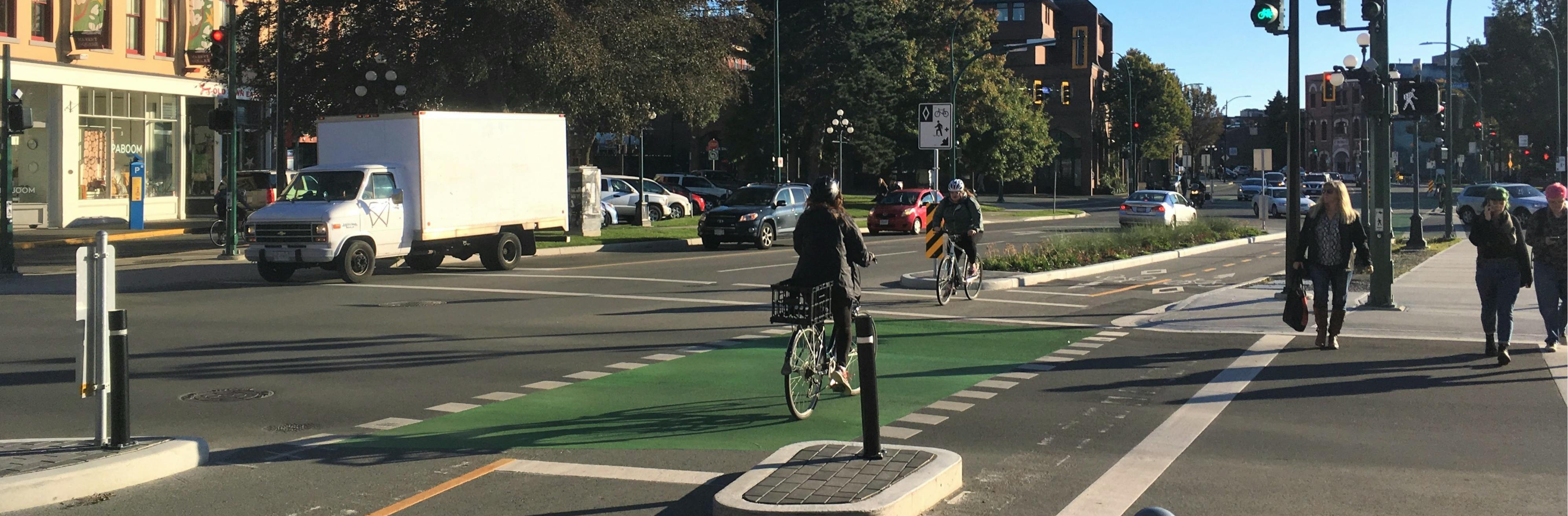
The Protected Cycling Network Study, concluded in April 2023, has developed conceptual designs for 8.8 kilometres of protected cycling infrastructure along three corridors (see map):
- Eramosa Road between Woolwich Street to Victoria Road (Study Area A)
- Gordon Street between Waterloo Avenue to Clair Road (Study Area B)
- College Avenue between Janefield Avenue to Dundas Lane (Study Area C).
Figure 1: Study Area
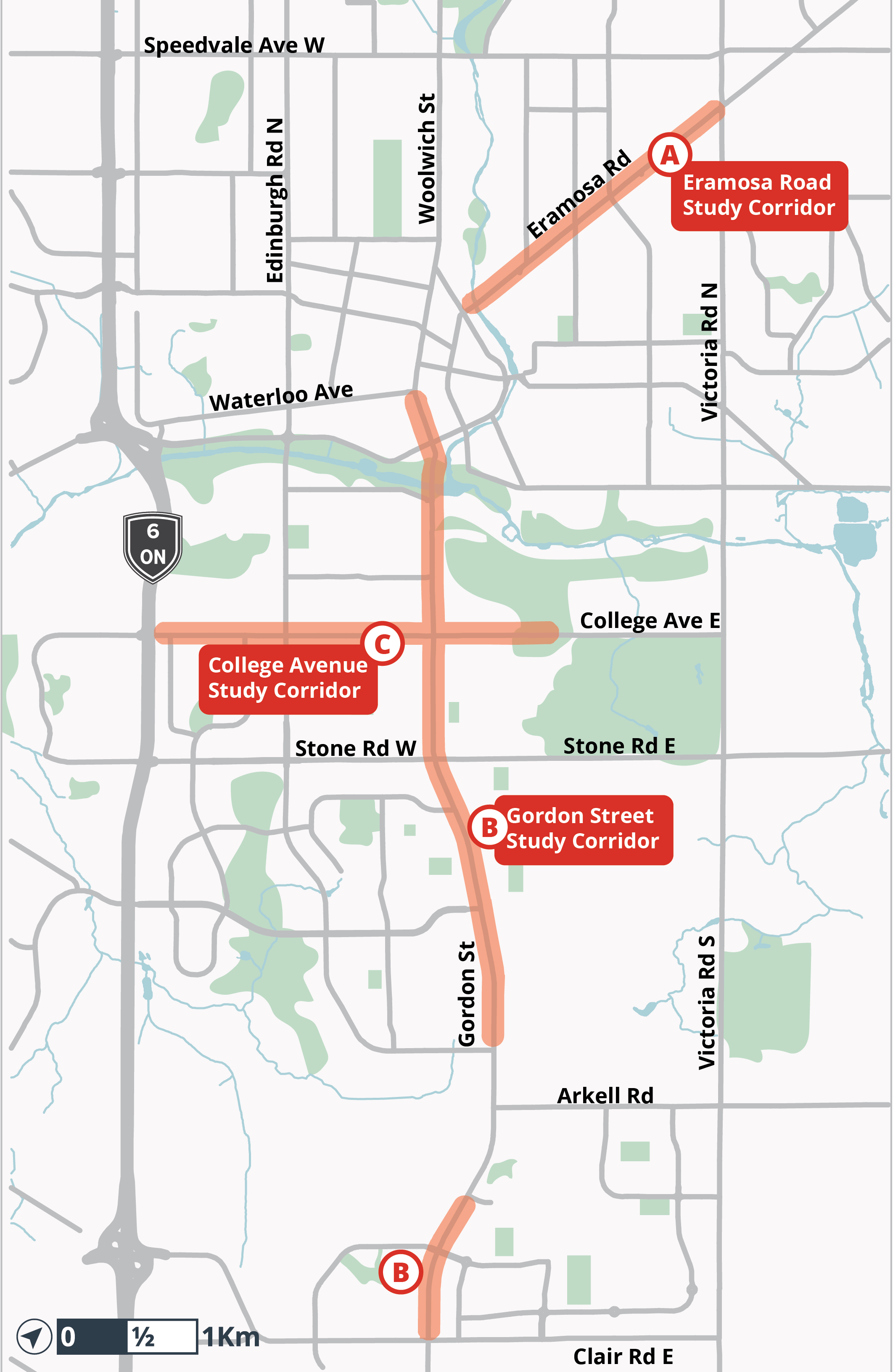 Study area map - click for full size
An Information Report was published on March 31st, 2023 to provide a summary of the Protected Cycling Network Study, and inform members of Council and the public of the next steps planned for the implementation of protected cycling facilities. The Protected Cycling Network Study report begins on page 76.
Detailed study reports for each corridor are posted on the project page at guelph.ca/cyclingnetwork
Next steps
The College Avenue protected cycling facilities will be the first of the three road corridors to move forward, with detailed design in 2023 and construction expected in 2024-2025.
The Gordon Street and Eramosa Road protected cycling facilities will proceed to detailed design and construction, subject to funding and approvals.
For more information
Kate Berry, Project Manager, Sustainable Transportation
Engineering and Transportation Services
City of Guelph
519-822-1260 extension 2357
Help create a connected cycling network for riders of all ages and abilities
Project update
The Protected Cycling Network Study, concluded in April 2023, has developed conceptual designs for 8.8 kilometres of protected cycling infrastructure along three corridors (see map):
- Eramosa Road between Woolwich Street to Victoria Road (Study Area A)
- Gordon Street between Waterloo Avenue to Clair Road (Study Area B)
- College Avenue between Janefield Avenue to Dundas Lane (Study Area C).
Figure 1: Study Area
Study area map - click for full size
An Information Report was published on March 31st, 2023 to provide a summary of the Protected Cycling Network Study, and inform members of Council and the public of the next steps planned for the implementation of protected cycling facilities. The Protected Cycling Network Study report begins on page 76.
Detailed study reports for each corridor are posted on the project page at guelph.ca/cyclingnetwork
Next steps
The College Avenue protected cycling facilities will be the first of the three road corridors to move forward, with detailed design in 2023 and construction expected in 2024-2025.
The Gordon Street and Eramosa Road protected cycling facilities will proceed to detailed design and construction, subject to funding and approvals.
For more information
Kate Berry, Project Manager, Sustainable Transportation
Engineering and Transportation Services
City of Guelph
519-822-1260 extension 2357
Do you any questions about the Guelph Cycling Network Study?
Feel free to submit your questions, one question per submission please! We will review all questions submitted and our team will post responses here.
-
Share I'm an avid cyclist and I'm very gretaful for the hard work that is going into this study and other work to make Guelph more cycling accessible. One very frustrating thing I find with the current network is the lack of priority given to cyclists at light controlled intersections, especially in places with bike lanes, or roads that have been designated as a bike route. I would suggest that on all designated bike routes, there should be infrastructure in place so that the lights can detect cyclists. This could be: traffic light activation buttons - easily accessible from the bike lane (similar to a pedestian ring button but in reach of the bike lane), in-ground loop systems that are capable of detecting cyclists, cameras capable of detecting cyclists, as a minimum traffic lights that change periodically (no detection required). Currently, a lot of lights on designated bike routes are "demand activated" and only detect vehicles. In these situations if there are no waiting vehicles it is often necessary to get off the bike, walk over to the pedestrian crossing, press the pedestrian button, back to the road, get back on your bike, enter the intersection - this does not feel like a priority is being given to bikes even though its on a designated bike route, and could be discouraging bike usage. In the new study areas, what infrastructure will be implemented to deal with this issue? on Facebook Share I'm an avid cyclist and I'm very gretaful for the hard work that is going into this study and other work to make Guelph more cycling accessible. One very frustrating thing I find with the current network is the lack of priority given to cyclists at light controlled intersections, especially in places with bike lanes, or roads that have been designated as a bike route. I would suggest that on all designated bike routes, there should be infrastructure in place so that the lights can detect cyclists. This could be: traffic light activation buttons - easily accessible from the bike lane (similar to a pedestian ring button but in reach of the bike lane), in-ground loop systems that are capable of detecting cyclists, cameras capable of detecting cyclists, as a minimum traffic lights that change periodically (no detection required). Currently, a lot of lights on designated bike routes are "demand activated" and only detect vehicles. In these situations if there are no waiting vehicles it is often necessary to get off the bike, walk over to the pedestrian crossing, press the pedestrian button, back to the road, get back on your bike, enter the intersection - this does not feel like a priority is being given to bikes even though its on a designated bike route, and could be discouraging bike usage. In the new study areas, what infrastructure will be implemented to deal with this issue? on Twitter Share I'm an avid cyclist and I'm very gretaful for the hard work that is going into this study and other work to make Guelph more cycling accessible. One very frustrating thing I find with the current network is the lack of priority given to cyclists at light controlled intersections, especially in places with bike lanes, or roads that have been designated as a bike route. I would suggest that on all designated bike routes, there should be infrastructure in place so that the lights can detect cyclists. This could be: traffic light activation buttons - easily accessible from the bike lane (similar to a pedestian ring button but in reach of the bike lane), in-ground loop systems that are capable of detecting cyclists, cameras capable of detecting cyclists, as a minimum traffic lights that change periodically (no detection required). Currently, a lot of lights on designated bike routes are "demand activated" and only detect vehicles. In these situations if there are no waiting vehicles it is often necessary to get off the bike, walk over to the pedestrian crossing, press the pedestrian button, back to the road, get back on your bike, enter the intersection - this does not feel like a priority is being given to bikes even though its on a designated bike route, and could be discouraging bike usage. In the new study areas, what infrastructure will be implemented to deal with this issue? on Linkedin Email I'm an avid cyclist and I'm very gretaful for the hard work that is going into this study and other work to make Guelph more cycling accessible. One very frustrating thing I find with the current network is the lack of priority given to cyclists at light controlled intersections, especially in places with bike lanes, or roads that have been designated as a bike route. I would suggest that on all designated bike routes, there should be infrastructure in place so that the lights can detect cyclists. This could be: traffic light activation buttons - easily accessible from the bike lane (similar to a pedestian ring button but in reach of the bike lane), in-ground loop systems that are capable of detecting cyclists, cameras capable of detecting cyclists, as a minimum traffic lights that change periodically (no detection required). Currently, a lot of lights on designated bike routes are "demand activated" and only detect vehicles. In these situations if there are no waiting vehicles it is often necessary to get off the bike, walk over to the pedestrian crossing, press the pedestrian button, back to the road, get back on your bike, enter the intersection - this does not feel like a priority is being given to bikes even though its on a designated bike route, and could be discouraging bike usage. In the new study areas, what infrastructure will be implemented to deal with this issue? link
I'm an avid cyclist and I'm very gretaful for the hard work that is going into this study and other work to make Guelph more cycling accessible. One very frustrating thing I find with the current network is the lack of priority given to cyclists at light controlled intersections, especially in places with bike lanes, or roads that have been designated as a bike route. I would suggest that on all designated bike routes, there should be infrastructure in place so that the lights can detect cyclists. This could be: traffic light activation buttons - easily accessible from the bike lane (similar to a pedestian ring button but in reach of the bike lane), in-ground loop systems that are capable of detecting cyclists, cameras capable of detecting cyclists, as a minimum traffic lights that change periodically (no detection required). Currently, a lot of lights on designated bike routes are "demand activated" and only detect vehicles. In these situations if there are no waiting vehicles it is often necessary to get off the bike, walk over to the pedestrian crossing, press the pedestrian button, back to the road, get back on your bike, enter the intersection - this does not feel like a priority is being given to bikes even though its on a designated bike route, and could be discouraging bike usage. In the new study areas, what infrastructure will be implemented to deal with this issue?
BenPhillips asked about 2 years agoThanks for your question! Within the study areas many intersections will be reconstructed and those will have either bicycle detection or easily activated bicycle signals. As well, all new and rebuilt intersections in the City are being equipped with overhead detection for cyclists. Unfortunately, it will take many years to upgrade all of the existing intersections. Sustainable Transportation staff are working with the Signals team to address priority locations on identified cycling routes.
-
Share Comment- I have been taking College to Scottsdale recently b/c of Stone Rd construction. The setup of safety barriers looks like they are going to be knocked over by buses come September. Also restricting parking for school drop of and creating traffic back log and idling. I understand the need for creating safer streets for cyclists but the need for safer roads is on the busy roads not a section of a street mainly used by school families, local residents and people accessing the mall parkade. I rarely see cyclists in this area. Aside from Scottsdale/Ironwood/Janefield area, why do the bike lanes on Starwood have speed bumps in them? on Facebook Share Comment- I have been taking College to Scottsdale recently b/c of Stone Rd construction. The setup of safety barriers looks like they are going to be knocked over by buses come September. Also restricting parking for school drop of and creating traffic back log and idling. I understand the need for creating safer streets for cyclists but the need for safer roads is on the busy roads not a section of a street mainly used by school families, local residents and people accessing the mall parkade. I rarely see cyclists in this area. Aside from Scottsdale/Ironwood/Janefield area, why do the bike lanes on Starwood have speed bumps in them? on Twitter Share Comment- I have been taking College to Scottsdale recently b/c of Stone Rd construction. The setup of safety barriers looks like they are going to be knocked over by buses come September. Also restricting parking for school drop of and creating traffic back log and idling. I understand the need for creating safer streets for cyclists but the need for safer roads is on the busy roads not a section of a street mainly used by school families, local residents and people accessing the mall parkade. I rarely see cyclists in this area. Aside from Scottsdale/Ironwood/Janefield area, why do the bike lanes on Starwood have speed bumps in them? on Linkedin Email Comment- I have been taking College to Scottsdale recently b/c of Stone Rd construction. The setup of safety barriers looks like they are going to be knocked over by buses come September. Also restricting parking for school drop of and creating traffic back log and idling. I understand the need for creating safer streets for cyclists but the need for safer roads is on the busy roads not a section of a street mainly used by school families, local residents and people accessing the mall parkade. I rarely see cyclists in this area. Aside from Scottsdale/Ironwood/Janefield area, why do the bike lanes on Starwood have speed bumps in them? link
Comment- I have been taking College to Scottsdale recently b/c of Stone Rd construction. The setup of safety barriers looks like they are going to be knocked over by buses come September. Also restricting parking for school drop of and creating traffic back log and idling. I understand the need for creating safer streets for cyclists but the need for safer roads is on the busy roads not a section of a street mainly used by school families, local residents and people accessing the mall parkade. I rarely see cyclists in this area. Aside from Scottsdale/Ironwood/Janefield area, why do the bike lanes on Starwood have speed bumps in them?
Christina J asked about 2 years agoHi Christina,
It seems like your questions are related to the new Traffic Calming project on Scottsdale Road. If you have questions about Traffic Calming in the City, I would encourage you to reach out to Traffic@guelph.ca. On Starwood there are speed cushions across the entire roadway (including in the buffered area of the bike lanes) so that people driving cannot evade these traffic calming measures by going around them into the bike lanes.
-
Share Is there really that many bike rides on this routes that justify the cost? Has there been substantial number of accidents that has made the current bike lanes unsafe. To my point, I haven't seen, read or heard any reports to substantiate the cost vs. safety for cyclist. on Facebook Share Is there really that many bike rides on this routes that justify the cost? Has there been substantial number of accidents that has made the current bike lanes unsafe. To my point, I haven't seen, read or heard any reports to substantiate the cost vs. safety for cyclist. on Twitter Share Is there really that many bike rides on this routes that justify the cost? Has there been substantial number of accidents that has made the current bike lanes unsafe. To my point, I haven't seen, read or heard any reports to substantiate the cost vs. safety for cyclist. on Linkedin Email Is there really that many bike rides on this routes that justify the cost? Has there been substantial number of accidents that has made the current bike lanes unsafe. To my point, I haven't seen, read or heard any reports to substantiate the cost vs. safety for cyclist. link
Is there really that many bike rides on this routes that justify the cost? Has there been substantial number of accidents that has made the current bike lanes unsafe. To my point, I haven't seen, read or heard any reports to substantiate the cost vs. safety for cyclist.
Brian Reilly asked about 2 years agoHi Brian,
While actual safety is an important consideration when investing in cycling infrastructure, perceived safety is just as critical (if not more!). If people don't feel like the bike lanes are safe, they will not use them. They will not permit their children to use them. Older adults and people with accessibility needs won't use them. If cycling infrastructure does not work for all residents, then cycling will always be underutilized. The goal of this project is to enhance both the actual and perceived safety of cycling infrastructure in the City, in alignment with the City's Transportation Master Plan and Community Plan; in order to ensure cycling is a viable and welcoming option for everyone.
In terms of the number of users, in some locations we count an average of anywhere between 350-650 cyclists per day.
Thank you for your question!
-
Share I'm a bit baffled by Eramosa. When I cycle to work I go around Eramosa, not because of traffic, but not to arrive at work covered in sweat. What is the goal of this particular corridor, and could that goal be achieved with an alternate route. on Facebook Share I'm a bit baffled by Eramosa. When I cycle to work I go around Eramosa, not because of traffic, but not to arrive at work covered in sweat. What is the goal of this particular corridor, and could that goal be achieved with an alternate route. on Twitter Share I'm a bit baffled by Eramosa. When I cycle to work I go around Eramosa, not because of traffic, but not to arrive at work covered in sweat. What is the goal of this particular corridor, and could that goal be achieved with an alternate route. on Linkedin Email I'm a bit baffled by Eramosa. When I cycle to work I go around Eramosa, not because of traffic, but not to arrive at work covered in sweat. What is the goal of this particular corridor, and could that goal be achieved with an alternate route. link
I'm a bit baffled by Eramosa. When I cycle to work I go around Eramosa, not because of traffic, but not to arrive at work covered in sweat. What is the goal of this particular corridor, and could that goal be achieved with an alternate route.
rwaterman asked about 2 years agoHi there. The goal of studying the Eramosa Road corridor was to determine whether cycling infrastructure could be incorporated along this direct and important transportation corridor. The results of the study indicate that there are too many technical constraints for us to proceed at this time. This presentation (with audio) and this slide deck (without audio) share more details about Eramosa. As an interim measure, to ensure people can still access destinations along this major roadway, alternate routes may be developed.
-
Share We have suggested either Moving the crosswalk on Eramosa from Mitchell st to Arthur street or provide fully signalized intersection at Arthur and Eramosa and are pleased that this is being considered.As this intersection is a signed Cycle Route the crossing will provide a much needed safer crossing and alternative (via the the Norwich st pedestrian bridge) to the unsafe TCT crossing further South on Eramosa. What is needed in the proposed new design is a way to cycle safely across the South side of Eramosa bridge to connect back to the TCT South .If the Bridge sidewalk was widened sufficiently to allow contraflow cycle track or a bi directional MUP this would provide a fairly level grade access to the TCT South .Most riders will not try and ride up Eramosa to Downtown as it has a steep slope so this idea will provide low grade access to the TCT and Downtown via the underside access of the Heffernan Street bridge by St Georges Church . Mike Darmon GCAT on Facebook Share We have suggested either Moving the crosswalk on Eramosa from Mitchell st to Arthur street or provide fully signalized intersection at Arthur and Eramosa and are pleased that this is being considered.As this intersection is a signed Cycle Route the crossing will provide a much needed safer crossing and alternative (via the the Norwich st pedestrian bridge) to the unsafe TCT crossing further South on Eramosa. What is needed in the proposed new design is a way to cycle safely across the South side of Eramosa bridge to connect back to the TCT South .If the Bridge sidewalk was widened sufficiently to allow contraflow cycle track or a bi directional MUP this would provide a fairly level grade access to the TCT South .Most riders will not try and ride up Eramosa to Downtown as it has a steep slope so this idea will provide low grade access to the TCT and Downtown via the underside access of the Heffernan Street bridge by St Georges Church . Mike Darmon GCAT on Twitter Share We have suggested either Moving the crosswalk on Eramosa from Mitchell st to Arthur street or provide fully signalized intersection at Arthur and Eramosa and are pleased that this is being considered.As this intersection is a signed Cycle Route the crossing will provide a much needed safer crossing and alternative (via the the Norwich st pedestrian bridge) to the unsafe TCT crossing further South on Eramosa. What is needed in the proposed new design is a way to cycle safely across the South side of Eramosa bridge to connect back to the TCT South .If the Bridge sidewalk was widened sufficiently to allow contraflow cycle track or a bi directional MUP this would provide a fairly level grade access to the TCT South .Most riders will not try and ride up Eramosa to Downtown as it has a steep slope so this idea will provide low grade access to the TCT and Downtown via the underside access of the Heffernan Street bridge by St Georges Church . Mike Darmon GCAT on Linkedin Email We have suggested either Moving the crosswalk on Eramosa from Mitchell st to Arthur street or provide fully signalized intersection at Arthur and Eramosa and are pleased that this is being considered.As this intersection is a signed Cycle Route the crossing will provide a much needed safer crossing and alternative (via the the Norwich st pedestrian bridge) to the unsafe TCT crossing further South on Eramosa. What is needed in the proposed new design is a way to cycle safely across the South side of Eramosa bridge to connect back to the TCT South .If the Bridge sidewalk was widened sufficiently to allow contraflow cycle track or a bi directional MUP this would provide a fairly level grade access to the TCT South .Most riders will not try and ride up Eramosa to Downtown as it has a steep slope so this idea will provide low grade access to the TCT and Downtown via the underside access of the Heffernan Street bridge by St Georges Church . Mike Darmon GCAT link
We have suggested either Moving the crosswalk on Eramosa from Mitchell st to Arthur street or provide fully signalized intersection at Arthur and Eramosa and are pleased that this is being considered.As this intersection is a signed Cycle Route the crossing will provide a much needed safer crossing and alternative (via the the Norwich st pedestrian bridge) to the unsafe TCT crossing further South on Eramosa. What is needed in the proposed new design is a way to cycle safely across the South side of Eramosa bridge to connect back to the TCT South .If the Bridge sidewalk was widened sufficiently to allow contraflow cycle track or a bi directional MUP this would provide a fairly level grade access to the TCT South .Most riders will not try and ride up Eramosa to Downtown as it has a steep slope so this idea will provide low grade access to the TCT and Downtown via the underside access of the Heffernan Street bridge by St Georges Church . Mike Darmon GCAT
Mike Darmon asked about 2 years agoThanks for your feedback, Mike! This suggestion has been shared with the consulting team.
-
Share Hello, I live on Woodridge drive in Guelph and there is no safe way to get from the west side of Guelph to the rest of Guelph on a bike. Would it be possible to make Paisly road 3 lanes of vehicle traffic from Elmira road to Hanlon expressway (1 common turn lane & 2 lanes for traffic) & have 2 bike lanes (1 for each side of road). This was done for Elmira road and vehicle traffice still moves smoothly but with the 2 bike lanes it is much safer. on Facebook Share Hello, I live on Woodridge drive in Guelph and there is no safe way to get from the west side of Guelph to the rest of Guelph on a bike. Would it be possible to make Paisly road 3 lanes of vehicle traffic from Elmira road to Hanlon expressway (1 common turn lane & 2 lanes for traffic) & have 2 bike lanes (1 for each side of road). This was done for Elmira road and vehicle traffice still moves smoothly but with the 2 bike lanes it is much safer. on Twitter Share Hello, I live on Woodridge drive in Guelph and there is no safe way to get from the west side of Guelph to the rest of Guelph on a bike. Would it be possible to make Paisly road 3 lanes of vehicle traffic from Elmira road to Hanlon expressway (1 common turn lane & 2 lanes for traffic) & have 2 bike lanes (1 for each side of road). This was done for Elmira road and vehicle traffice still moves smoothly but with the 2 bike lanes it is much safer. on Linkedin Email Hello, I live on Woodridge drive in Guelph and there is no safe way to get from the west side of Guelph to the rest of Guelph on a bike. Would it be possible to make Paisly road 3 lanes of vehicle traffic from Elmira road to Hanlon expressway (1 common turn lane & 2 lanes for traffic) & have 2 bike lanes (1 for each side of road). This was done for Elmira road and vehicle traffice still moves smoothly but with the 2 bike lanes it is much safer. link
Hello, I live on Woodridge drive in Guelph and there is no safe way to get from the west side of Guelph to the rest of Guelph on a bike. Would it be possible to make Paisly road 3 lanes of vehicle traffic from Elmira road to Hanlon expressway (1 common turn lane & 2 lanes for traffic) & have 2 bike lanes (1 for each side of road). This was done for Elmira road and vehicle traffice still moves smoothly but with the 2 bike lanes it is much safer.
Jeff Struyk asked about 2 years agoHi there. The best bike route currently available to cross the Hanlon Expressway, is to use the Active Transportation Network connection across Westwood Road. I am also happy to confirm that Paisley Road is on the Transportation Master Plan's Cycling Spine Network, and will receive protected cycling infrastructure at some point in the future. A timeline for the design and construction of that corridor is not yet determined.
-
Share It’s funny you want questions regarding bike lanes but not about narrowing of roads and bumps to slow cars down, I’m all for making our streets safe, but I think we’re going to extremes. It would be nice to have a choice we generally only find out about changes once they’re made, the minority seems to have the loudest voice. on Facebook Share It’s funny you want questions regarding bike lanes but not about narrowing of roads and bumps to slow cars down, I’m all for making our streets safe, but I think we’re going to extremes. It would be nice to have a choice we generally only find out about changes once they’re made, the minority seems to have the loudest voice. on Twitter Share It’s funny you want questions regarding bike lanes but not about narrowing of roads and bumps to slow cars down, I’m all for making our streets safe, but I think we’re going to extremes. It would be nice to have a choice we generally only find out about changes once they’re made, the minority seems to have the loudest voice. on Linkedin Email It’s funny you want questions regarding bike lanes but not about narrowing of roads and bumps to slow cars down, I’m all for making our streets safe, but I think we’re going to extremes. It would be nice to have a choice we generally only find out about changes once they’re made, the minority seems to have the loudest voice. link
It’s funny you want questions regarding bike lanes but not about narrowing of roads and bumps to slow cars down, I’m all for making our streets safe, but I think we’re going to extremes. It would be nice to have a choice we generally only find out about changes once they’re made, the minority seems to have the loudest voice.
Bella asked about 2 years agoHello Bella,
This project is specifically about making some of the main corridors in our city safe for cyclists and to ensure people can bike to their final destinations, such as commercial centers and educational institutions, which are often located on busy arterial roads. This project was informed by the Transportation Master Plan, which began in 2019 and engaged thousands of people over two years to inform all aspects of transportation in Guelph. Safe cycling through the city was also a common theme we heard from our Community Plan engagement where we talked to thousands more. Every year we also engage people about traffic calming measures such as the ones you have described to slow cars down, but those are separate projects. Both our transportation team and our engagement team are always looking for ways to improve our outreach so that all residents of Guelph hear about our projects and can comment well before they are implemented – like this one! If you have ideas for improving our engagement in the City please let us know by emailing communityengagement@guelph.ca.
-
Share Hey, in current bike lanes the bus has cut me off many times even without signing. I hope the planned lanes are separate from the bus as this is the main reason I don’t use bike lanes. on Facebook Share Hey, in current bike lanes the bus has cut me off many times even without signing. I hope the planned lanes are separate from the bus as this is the main reason I don’t use bike lanes. on Twitter Share Hey, in current bike lanes the bus has cut me off many times even without signing. I hope the planned lanes are separate from the bus as this is the main reason I don’t use bike lanes. on Linkedin Email Hey, in current bike lanes the bus has cut me off many times even without signing. I hope the planned lanes are separate from the bus as this is the main reason I don’t use bike lanes. link
Hey, in current bike lanes the bus has cut me off many times even without signing. I hope the planned lanes are separate from the bus as this is the main reason I don’t use bike lanes.
S1im3 asked over 2 years agoHello, thank you for your comment. The proposed facilities are fully separated from vehicular lanes, including where transit stops exist. Special attention will be paid to transit stops to ensure all users can safely navigate these shared spaces. Buses will not be able to enter into the proposed cycling lanes.
-
Share "Signed Routes". Some internal feeder roads are designated as a "signed route", marked with signs that say, "Cycle Route". In practise, this is meaningless as they are no different from any other feeder roads. Yet, such "cycle routes" are merged along with cycle tracks and multi-use paths in Guelph's bike map (https://www.haveyoursay.guelph.ca/cycling-network-study/maps/map). This is "greenwashing" as it exaggerates the extent of safe bike routes to the uninformed viewer. At the very least, these should be marked in a different colour from that which marks cycle tracks and multi-use paths although, ideally, they should be removed from the map. on Facebook Share "Signed Routes". Some internal feeder roads are designated as a "signed route", marked with signs that say, "Cycle Route". In practise, this is meaningless as they are no different from any other feeder roads. Yet, such "cycle routes" are merged along with cycle tracks and multi-use paths in Guelph's bike map (https://www.haveyoursay.guelph.ca/cycling-network-study/maps/map). This is "greenwashing" as it exaggerates the extent of safe bike routes to the uninformed viewer. At the very least, these should be marked in a different colour from that which marks cycle tracks and multi-use paths although, ideally, they should be removed from the map. on Twitter Share "Signed Routes". Some internal feeder roads are designated as a "signed route", marked with signs that say, "Cycle Route". In practise, this is meaningless as they are no different from any other feeder roads. Yet, such "cycle routes" are merged along with cycle tracks and multi-use paths in Guelph's bike map (https://www.haveyoursay.guelph.ca/cycling-network-study/maps/map). This is "greenwashing" as it exaggerates the extent of safe bike routes to the uninformed viewer. At the very least, these should be marked in a different colour from that which marks cycle tracks and multi-use paths although, ideally, they should be removed from the map. on Linkedin Email "Signed Routes". Some internal feeder roads are designated as a "signed route", marked with signs that say, "Cycle Route". In practise, this is meaningless as they are no different from any other feeder roads. Yet, such "cycle routes" are merged along with cycle tracks and multi-use paths in Guelph's bike map (https://www.haveyoursay.guelph.ca/cycling-network-study/maps/map). This is "greenwashing" as it exaggerates the extent of safe bike routes to the uninformed viewer. At the very least, these should be marked in a different colour from that which marks cycle tracks and multi-use paths although, ideally, they should be removed from the map. link
"Signed Routes". Some internal feeder roads are designated as a "signed route", marked with signs that say, "Cycle Route". In practise, this is meaningless as they are no different from any other feeder roads. Yet, such "cycle routes" are merged along with cycle tracks and multi-use paths in Guelph's bike map (https://www.haveyoursay.guelph.ca/cycling-network-study/maps/map). This is "greenwashing" as it exaggerates the extent of safe bike routes to the uninformed viewer. At the very least, these should be marked in a different colour from that which marks cycle tracks and multi-use paths although, ideally, they should be removed from the map.
Rudolf.Fernandes asked over 2 years agoThank you for this feedback, we will discuss this suggestion with the consulting team.
-
Share It's nice that Guelph is working on the 3 main corridors. But this is going to be quite useless for the "target" cyclist (everybody, not just those in multi-coloured spandex) if the feeder roads leading to those corridors do not provide adequate bike support. The city's emphasis on such feeder routes should switch from catering to 4 wheelers first to putting cyclists first. For example, when examining the width of a road, the first question should not be, "Is it wide enough for for one-sided parking?"; rather, it should be, "Is it wide enough for bike lanes?". There are a ton of such feeder roads that could benefit from such change in emphasis. Not only will regular cyclists be encouraged, but such bike lanes are proven to be traffic-calming. And... such modifications will likely be quite inexpensive. on Facebook Share It's nice that Guelph is working on the 3 main corridors. But this is going to be quite useless for the "target" cyclist (everybody, not just those in multi-coloured spandex) if the feeder roads leading to those corridors do not provide adequate bike support. The city's emphasis on such feeder routes should switch from catering to 4 wheelers first to putting cyclists first. For example, when examining the width of a road, the first question should not be, "Is it wide enough for for one-sided parking?"; rather, it should be, "Is it wide enough for bike lanes?". There are a ton of such feeder roads that could benefit from such change in emphasis. Not only will regular cyclists be encouraged, but such bike lanes are proven to be traffic-calming. And... such modifications will likely be quite inexpensive. on Twitter Share It's nice that Guelph is working on the 3 main corridors. But this is going to be quite useless for the "target" cyclist (everybody, not just those in multi-coloured spandex) if the feeder roads leading to those corridors do not provide adequate bike support. The city's emphasis on such feeder routes should switch from catering to 4 wheelers first to putting cyclists first. For example, when examining the width of a road, the first question should not be, "Is it wide enough for for one-sided parking?"; rather, it should be, "Is it wide enough for bike lanes?". There are a ton of such feeder roads that could benefit from such change in emphasis. Not only will regular cyclists be encouraged, but such bike lanes are proven to be traffic-calming. And... such modifications will likely be quite inexpensive. on Linkedin Email It's nice that Guelph is working on the 3 main corridors. But this is going to be quite useless for the "target" cyclist (everybody, not just those in multi-coloured spandex) if the feeder roads leading to those corridors do not provide adequate bike support. The city's emphasis on such feeder routes should switch from catering to 4 wheelers first to putting cyclists first. For example, when examining the width of a road, the first question should not be, "Is it wide enough for for one-sided parking?"; rather, it should be, "Is it wide enough for bike lanes?". There are a ton of such feeder roads that could benefit from such change in emphasis. Not only will regular cyclists be encouraged, but such bike lanes are proven to be traffic-calming. And... such modifications will likely be quite inexpensive. link
It's nice that Guelph is working on the 3 main corridors. But this is going to be quite useless for the "target" cyclist (everybody, not just those in multi-coloured spandex) if the feeder roads leading to those corridors do not provide adequate bike support. The city's emphasis on such feeder routes should switch from catering to 4 wheelers first to putting cyclists first. For example, when examining the width of a road, the first question should not be, "Is it wide enough for for one-sided parking?"; rather, it should be, "Is it wide enough for bike lanes?". There are a ton of such feeder roads that could benefit from such change in emphasis. Not only will regular cyclists be encouraged, but such bike lanes are proven to be traffic-calming. And... such modifications will likely be quite inexpensive.
Rudolf.Fernandes asked over 2 years agoHello, thank you for your feedback. Adjacent routes such as feeder roads on the local and collector network will be further upgraded through the City's Cycling Master Plan update, commencing in 2023.
Follow Project
Videos
-
Click here to play video AAA Cycling Facilities Explainer Video
Project Lifecycle
-
Launch
Cycling Network Study has finished this stageLaunch the study - November 2021
Ask us a question or map your comments until January 10
-
Design
Cycling Network Study has finished this stageDesign alternative protected cycling solutions for each corridor - November 2021 to February 2022
-
Evaluate
Cycling Network Study has finished this stageEvaluate alternative design concepts and select the preferred approach - February to Spring 2022
-
Plan
Cycling Network Study has finished this stagePlan for implementation - Summer 2022
-
Next steps
Cycling Network Study is currently at this stageDetailed design and construction, subject to City of Guelph capital budget.
Who's Listening
-
Phone 519-822-1260 x2791 Email jennifer.juste@guelph.ca -
Email mking@dillon.ca
Key Dates
-
July 27 2022
-
November 30 2021 → January 10 2022
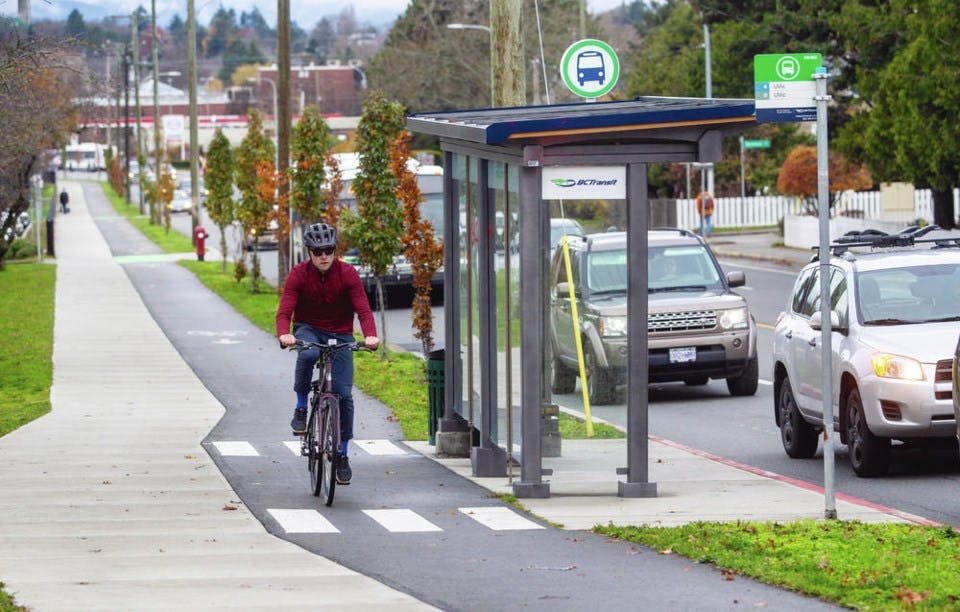
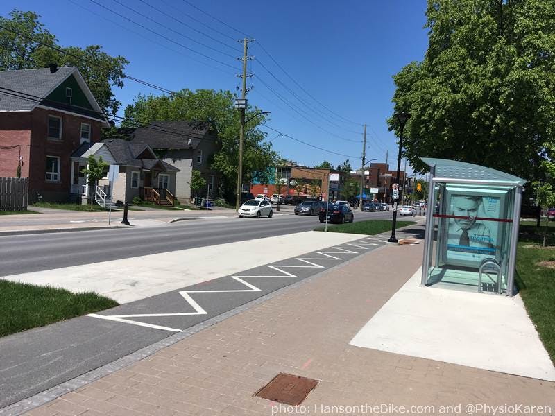
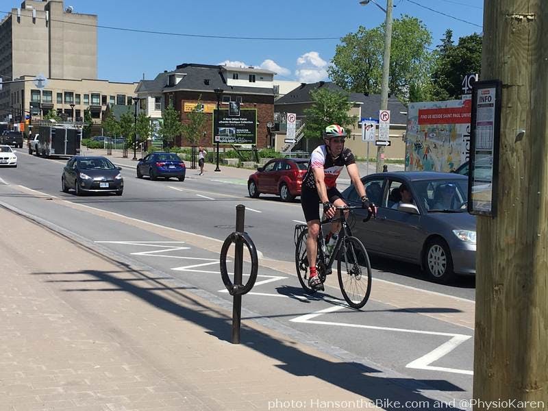
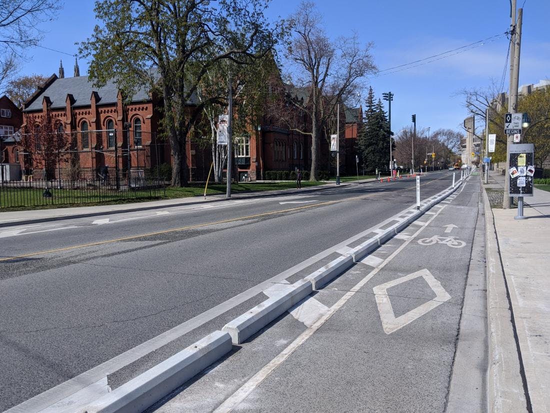
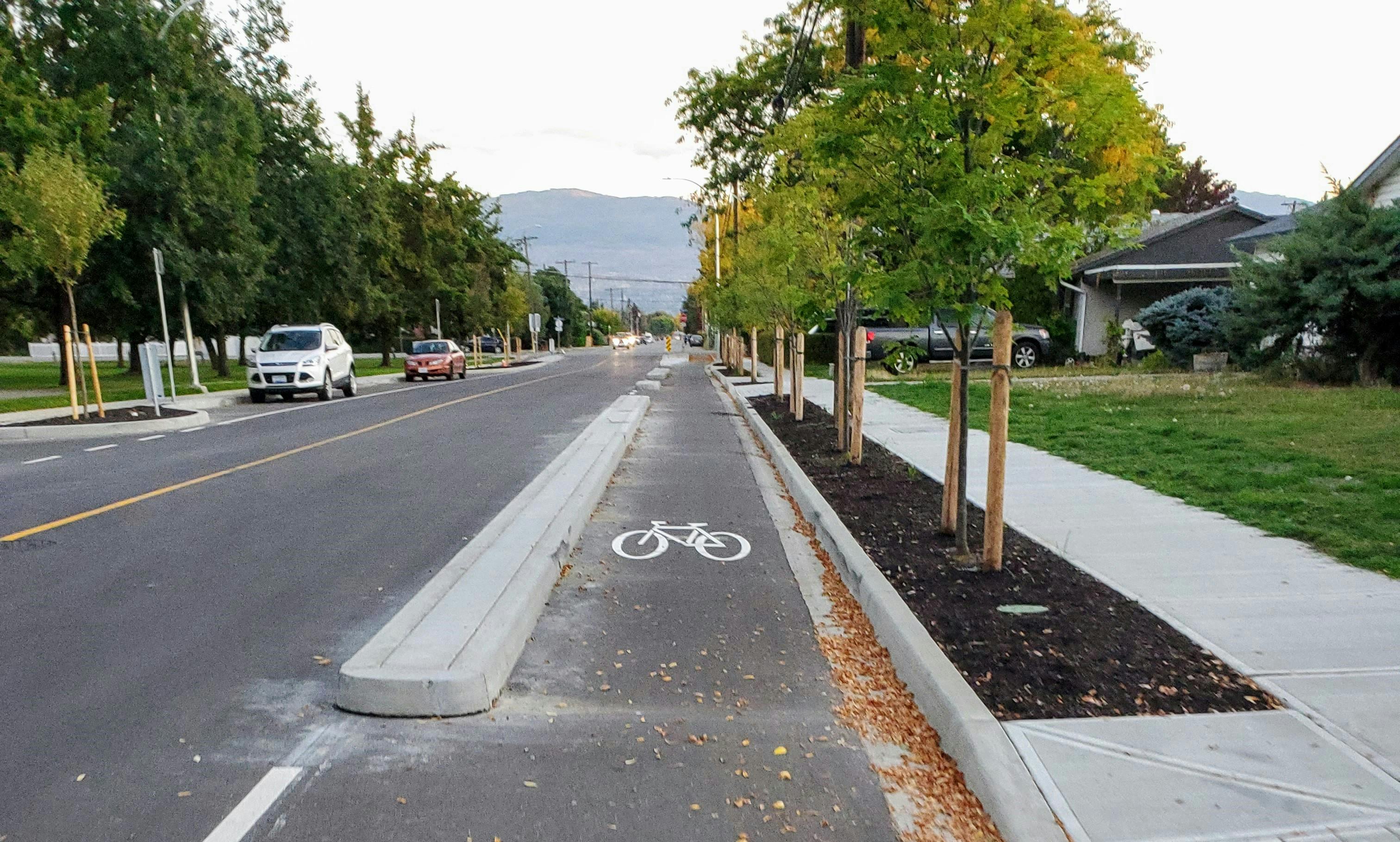
Cycle Track Example Images
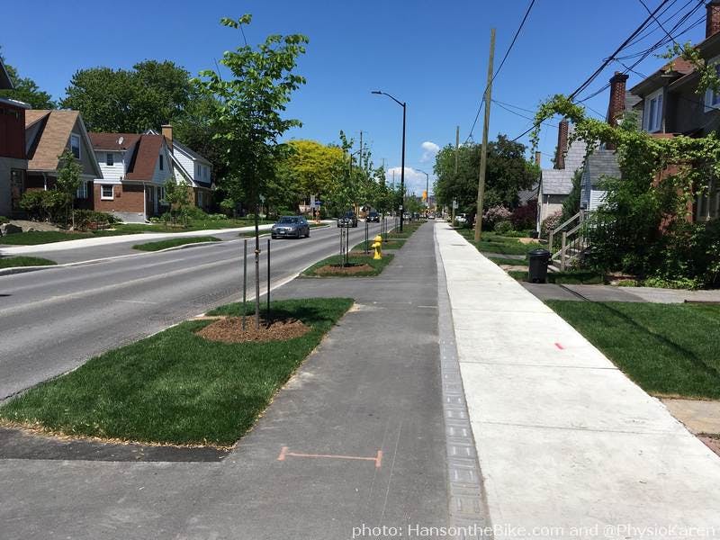
Multi-Use Path Example Images
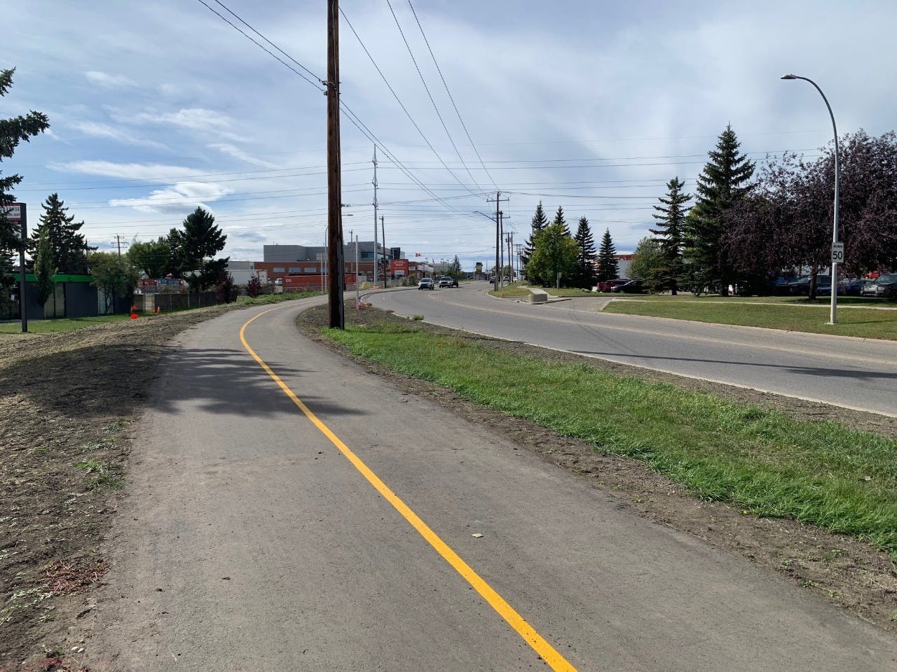
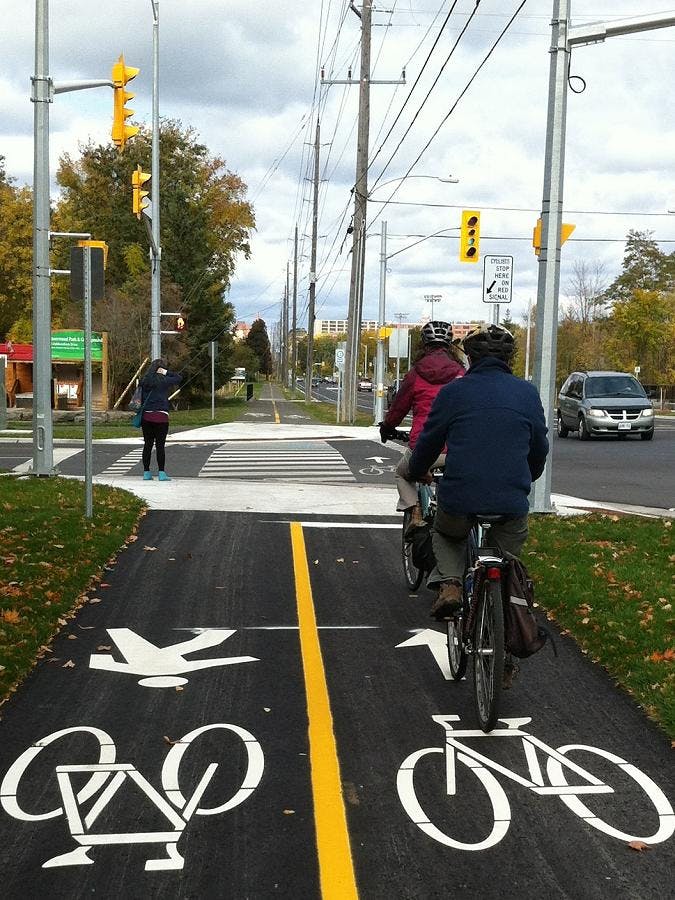
Protected Bike Lane Example Images
Documents
-
 Guelph Protected Cycling Network Engagement Report.pdf (1.43 MB) (pdf)
-
Notice of Correction_.pdf (182 KB) (pdf)
-
Guelph Protected Cycling engagement summary.pdf (236 KB) (pdf)
-
Notice of Consultation - Guelph Protected Cycling Network (234 KB) (pdf)
-
Evaluation Criteria.pdf (311 KB) (pdf)
-
Evaluation of Alternatives - College Avenue.pdf (524 KB) (pdf)
-
Evaluation of Alternatives - Gordon Street.pdf (546 KB) (pdf)
-
Evaluation of Alternatives - Eramosa Road.pdf (510 KB) (pdf)
-
Remix Legend.pdf (152 KB) (pdf)
-
 Open House - July 2022


Thank you for your contribution!
Help us reach out to more people in the community
Share this with family and friends